Reflecting on The Great Trail in Northern Ontario
By the time we reached North Bay we had begun to encounter roads signs indicating that Ottawa was a mere 350 km away. For us this was a somewhat discouraging sight given the more than 1500 km that we had trekked across Ontario since leaving the nation’s capital some 70 days ago!

In that time we had traversed approximately 580 km from Ottawa to Durham completing Eastern Ontario, ventured 650 km from Durham to Orillia across the Greater Toronto region, and gone on to hike 350 km from Copper Falls / Gravenhurst to North Bay to complete what we had deemed to be the Muskoka stretch of the Great Trail.
The next, and final, portion of Ontario would be the longest including more than 800 km of land trail across Northern Ontario. This section stretches from North Bay through Sudbury to Sault Ste Marie, and continuing on to include trail segments such as paths in Lake Superior Provincial Park, the towns of Wawa and Marathon, the Casques Isles Trail, the communities of Nipigon and Red Rock, Sleeping Giant Provincial Park, the urban trails of Thunder Bay, the town of Kenora and of course the trek to the Manitoba border.
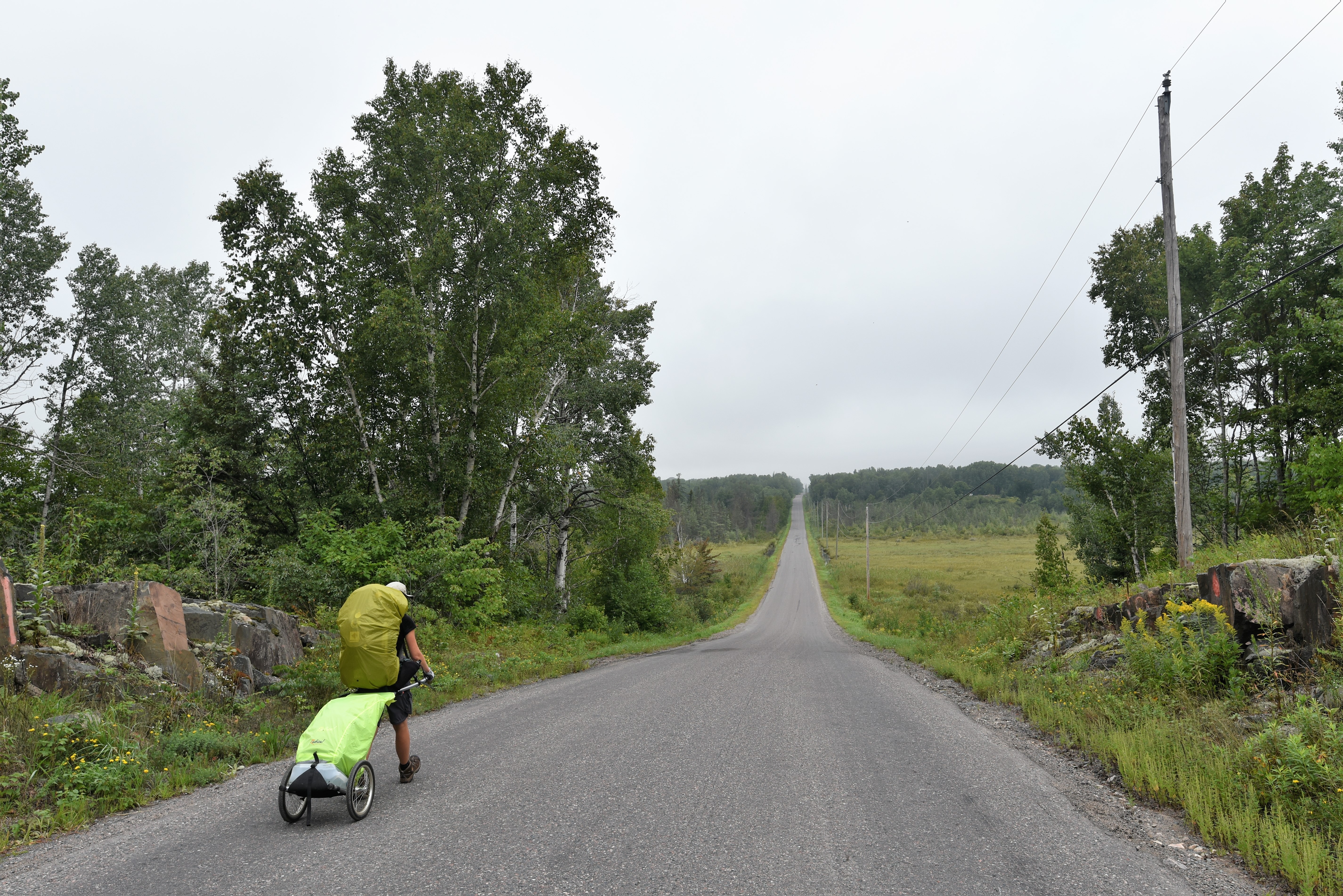
Just as the transition into the Muskokas was a radical change in the nature of the Great Trail, so too was the departure from North Bay heading westward along the narrow gravel shoulder on Voyageur Cycling Route - also known as HWY 17 – also known as the Trans Canada Highway. This reality soon meant that many of our days involved 30-55 km of highway and road walking which was an unnerving and noisy experience.


Here as cars, trucks, and transports raced by, those not busy on their phones or focused on the road were distracted by the fact that someone was walking on the side of the highway. As such, horns were often sounded, middle fingers were unleashed, and garbage was (from time to time) hurdled out by passing vehicles. The space between the guardrail (where it existed) and the road was often so narrow that one could feel the vehicles race past meaning that much of our time on the ‘trail’ was a battle against our fraying nerves and the vicious blasts of wind buffering off trucks. In contrast the space between the guardrail and the dynamited remains of the rocky landscape was often so uneven that our pace would only be slowed further to be practical. This unnerving situation was made worse by the fact that the roadsides and ditches around us were heavily littered with rivers of disguarded beer cans and plastic whisky bottles. Further adding to the challenge of these stretches is the fact that it is almost impossible to stop walking as there are few places in which one can get away from the roadside enough to put down your backpack or escape the noise.

With all of that said however, when the landscape opened up beyond the traffic corridor it is without question one of the most magnificent parts of the country we have yet to see. Here the boreal forest, sweeping valleys of green, the varied colours and solidness of the Canadian Shield all give way to some of Canada’s most impressive wild spaces. In such places, the scale of our landscape is humbling, it is here you begin to see what our predecessors saw – a nature that eclipses us and that reminds one that you are merely part of the natural order.


As the trail continued, along it’s indirect route we wove south, away from the main highway leading to the town of Lavigne, through the beautiful Mashkinonje Provincial Park, to the welcoming community of Noelville where we resupplied and enjoyed perhaps the greatest breakfast of the year – huge vegetable and cheese omelettes, with buttered toasted and several cups of warm coffee - on the balcony of a local restaurant! A shear luxury but we revelled in it!


In Novelville, the Voyageur Cycling Route would return north taking us back onto the Trans Canada Highway travelling from Hagar, through Markstay, Stinson, Wahnapitae, around Ramsey Lake and into the city of Sudbury. Throughout this run alongside the Trans Canada Highway there are no words that can convey the nervous tension that pulsed through our bodies (in time with the vehicles which passed us). The simple fact was that we were small pedestrians amid a constant track of face paced steel machines. Tired by the continual heat and humidity of the late summer and the radiant heat from the road we felt small and fragile. It was either through sheer luck or the grace of God that we got through this more than 200 km stretch of trekking unscathed.


While there are undeniably segments of great beauty throughout this area our ability appreciate them given the circumstances was highly diminished. It is undeniably unfortunate that so much of the Great Trail in areas such as this is tied to roadways and highways rather than pathways. However as the Trans Canada Trail organization optimistically states ‘the trail is CONNECTED not COMPLETED’.


Having arrived on the outskirts of the city of Sudbury the Great Trail turned into a hiking pathway once again! Here we toured around the beautiful Ramsey Lake, Bethel Lake, and through Laurentian University’s campus on a local pathway over the rugged terrain.


For the fourth time on this year’s trek (Peterborough, Ajax, Toronto) we had arrived to a city that we had at one point lived in. Here for two years Sean had attended Graduate School and worked as a Teaching Assistant and Researcher at Laurentian University. As such as we had wonderful memories of taking younger family members to Moonlight Beach, hiking around the university campus at Bethel Lake, and visiting the Science North, Dynamic Earth and the Big Nickel! Many of these memories we would get a chance to relive as we took a few days in town to recharge and resupply before continuing westward.


In town, the Great Trail’s route took us along the lake shoreline on an amazing accessible boardwalk past Ampitheatre Beach, New Beach and Bell Park Main Beach to the McNaughton Waterfront Park. En route we passed couples enjoying a walk through the park, paddle boarders and their dogs in the water, as well as students studying under the shade of trees. Here we were also fortunate to be interviewed by the talented Molly Frommer of CTV about our trek and its message encouraging youth to get into nature through Citizen Science.
Setting out from Sudbury, we not only ventured through town along a series of connected urban paths but we did so following the Sudbury Pilgrimage Trail! This Canadian Camino was a sheer delight to undertake, and evoked memories of our time on the Camino de Santiago and Camino Portuguese years past. The route of the Great Trail and Pilgrimage Trail wove us around town, through corridors of lush green trees and around lakes and along beautiful boardwalks into duck filled marshes!


To be honest, none of what we experienced on the trails here was what one expects of a city deemed to be a mining centre. The natural beauty we enjoyed and the dedication to make it such a wonderful region to trek around in Sudbury was amazing!


Continuing on we would now follow one of the largest sections of Ontario’s Great Trail, the Huron Shores, a route which connects Sudbury to Sault Ste. Marie covering almost 400 km in length. Here, as it had from North Bay to Sudbury, the path of the Great Trail would either take us along the side of the Trans Canada Highway, parallel it, or send us along busy regional roads. Adding to the situation was Ontario’s pension for continual road construction, which meant that our route was subject to being diverted (on an almost daily basis) due to road repair or bridge construction. These reroutes transformed most of our days from 25 or 30 km hikes into ones which were between 35 and 45 km of trekking.

It was throughout this stretch that we also began to struggle with the differing reactions and acceptances of Covid which varied from community to community. In one town the virus would be deemed a foreign conspiracy, in the next masking was a necessity, in the next we were lectured for travelling, while in another residents lamented the loss of summer tourist business profits. In one community there were quickly created ‘extra taxes for visitors to cover the loss of business in 2020’, yet just a few kilometres down the road we would be deemed fools for abiding by public health warnings. The pinnacle came in one municipality where, while resupplying, we were bluntly informed in the local variety store that all items would cost more for us to purchase since we ‘were from out of town and these products were supposed to be for locals not Toronto folk’. Our circumstances invariably meant that we needed food and so we paid the revised prices, stored our food into our backpacks under the watchful smirk of the owner before continuing on. There is little denying that the challenges of the trail amid Covid were complicated by the uncertainties of the moment and varied anxieties of those we encountered.


Yet at the most difficult moments, just when you begin to doubt your endeavour and all those you might meet with, it is the simple kindnesses and random acts that bring you back to the realization that the world is indeed a wonderful place filled with wonderful people. Time and again throughout the north we were cared for in unexpected ways that lightened our loads and kept us going. It is because of these moments, that we were able to mentally step back and not see the hostile acts, hateful words, and assumptions, but instead recognized the uncertainties and anxieties of the people living amid challenging circumstances. You begin to see store owners whose businesses are on the edge of ruin, empty restaurants with waitresses nervous about getting more shifts, and lakes ringed with empty motels and rental cottages. You see that each of these institutions and individuals are those who regularly struggle from season to season and who are now witnessing a crisis that cannot be understood, cannot be seen, and for which there are no immediate solutions. It is a moment that is only made worse by the fact that there is no one to blame, nothing than can be repaired, and no action that can be taken to get past it, it is a moment that can only be endured and gotten through.
While we were not subject to many of these stresses like losing our jobs, being unable to keep our home, or ensuring that we have enough food for our families, we could empathize with everyone who was facing this moment with no certainty for what comes next.

Perhaps it is because of these anxieties that the kindnesses shown us stood out all the more. In the community of Nairn Centre where we stepped into a local restaurant to have dinner we met and briefly chatted with a friendly elderly couple who were enjoying their own meal. An hour later when we went to pay our bill and leave we discovered that without a word to us this amazing couple had already covered the cost of our meal. We never got a chance to thank them.


While camping one evening in a small forested plot, a man on an ATV stopped to warn us about bears and bear sightings in the region before making sure that we were ok and safe for the night. We never caught his name.
In the community of Spanish, we would be treated to an amazing boat ride during which we were able to explore the region and enjoy the local lakes amid a wondrous sunset! All arranged by the friendly owners of the local campground for those in their community to enjoy.


Later while on the road near Iron Bridge a family would unexpectedly pull over on the side of the road to make sure that we were safe while offering us fresh fruit and to top up our water bottles!
Amazingly these were just a few of the many positive encounters and sources of support we regularly received from a range of peoples and kind strangers on our hike across Northern Ontario.


As we continued on along the Great Trail, composed here of country roadways we had the opportunity to visit communities such as Espanol where we learned about the region’s hydro electric facilities and Massey were we took in the local forestry history.

En route we had the unique opportunity to meet up with Julie and Simon of JUSI Adventures, another couple of who have intrepidly crossed much of Canada on the Great Trail from Newfoundland through to Northern Ontario. As it turned out they had been trekking parts of the regional trail. Here they noticed us while driving by on the highway and took the occasion to turn around and meet up! Amid our quick chat they were both kind enough to top up our supplies by providing us with amazing freeze dried foods and camping treats!

At one point through this section the inevitable risks of the road caught up with us when a pickup truck loaded with unsecured debris raced past. It was in this moment, that a piece of wood flew out of the back end catching Sean in the shoulder, putting him in the ditch, and destroying his camera – usually mounted on his backpack strap. While he was not evidently injured it was a stark warning of how quickly everything can change from moment to moment. The lesson was not lost on us. Thankfully we were able to travel on but our ability to photograph the region was hampered for several days before a replacement camera could be found.

More aware of the hazards of our surroundings, we followed the Great Trail through this region which continued along the local concessions and roadways through the communities of Spanish, Serpent River, Spragge, into North Channel Inshore Provincial Park and to the town of Blind River. Westward bound, the trail followed the Mississaugi River and HWY 17 to the town of Iron Bridge where we had the opportunity to stay at a wonderful retro motel – the Red Top Motor Inn - run by two amazing individuals who are also great cooks!


What a refreshing place to stop and be reminded that throughout the world there are still places so fundamentally unique as this! Here we resupplied and rested for a few days, and took the opportunity to explore and confirm that the Voyageur Trail branch of the Great Trail in the region was largely impractical as a footpath from Iron Bridge to Sault Ste Marie.


Voyaging west the Great Trail continued along local concessions and roadways through the community of Bruce Mines were we stayed at the municipal campground. Similarly in the town of Thessalon we were able to camp at the immaculate municipal campground near the beach. Here, at the town diner, we were delighted to discover that the waitress as well as several of the customers remembered Dianne Whelan passing through the region leading to a wonderful evening of chatting with local residents about her adventures!


Throughout this stretch we returned to pastoral landscapes and agricultural fields of Mennonite communities. Here we would enjoy the slower pace of the countryside, and delight in the baked products we could purchase at the Mennonite county market. As we had in Kitchener and St. Jacobs, the sight of two hikers walking on the roads brought a mixture of inquisitiveness and awe from the local youth riding in carriages past us.


In general this part of the Great Trail was undertaken on less busy and dusty concession roadways. While our pace was both relaxed and quick for the conditions it was also warmer owing to the lack of shade which also subsequently made it more challenging to find places to rest and camp. The result of these conditions would lead us to have a number of long hiking days such as the 45 km jaunt into Echo Bay.


Here, with the local restaurants and campgrounds closed we spent an unusual evening camping under a large monument of a Loonie Dollar coin. Exposed on the edge of the road we were nervous, however by morning we would discover that we were by far the only visitors to spend the night at this location as much of the parking lot was filled with camper vans and RVs that had rolled up for the evening.

Having unsuspectingly set up our tent in a marshy area we awoke at 5 am to discover that we were floating in about 3 inches of water. Soaked through we made a hasty and warming breakfast prior to continuing on along the shores of Lake George and Little Lake George on the side of HWY 17B. Drying off as we trekked we made our way into the border city of Sault Ste Marie.


In town we wove through neighbourhoods, city parks, and along the waterfront into the downtown core. Here we would again check into a local motel to refuel and update the blog while planning the upcoming venture around Lake Superior to Thunder Bay and onward to the Ontario-Manitoba border.


The challenge from this point west was that in Sault Ste Marie the Great Trail (for the most part) ceased being a continuous land trail and became a paddling route traversing almost 1000 km along the coastline of Lake Superior. While we had considered kayaking this stretch, given the fact that it was now late in the fall season combined with the realities of Covid meant that we were soon forced to give up on the notion of traversing the nation’s largest Great Lake. The result of this decision was that we then had to choose whether to walk for 4-6 weeks along the Trans Canada Highway to get to Thunder Bay or whether to acknowledge that this was not part of the trail and find an alternative means to our next destination.


While investigating our options we were contacted by a local trail builder encouraging us to still trek the sections of land trail in Superior Country. During our talks we asked him about walking along the Trans Canada Highway to which he admitted, that in having met a previous Trans-Canada trekker who had walked the highway route, that they “had done it and clearly had the spirit to do it all, but that there was no denying that they looked very grim for the decision and experience”. As such, having already endured about 750 km of the highway we had no desire to continue the experience. Our decision was then to find transportation around Lake Superior and to find a way to complete the various trail sections of the physical pathway scattered around the largest Great Lake including Lake Superior Provincial Park, Wawa, Pukaskwa National Park, Marathon, Casque Isles, Nipigon to Red Rock, Sleeping Giant Provincial Park, and Thunder Bay’s urban trails.

Unfortunately the logistics of figuring out transportation, arranging lodgings, park permits, trail access, and water taxis amid a late season tourist rush gave way to a mountain of new complexities. We could travel around Lake Superior via the Ontario Northlander bus, however the irregular schedule meant that we would spend half a week in Sault Ste Marie and need to time each trail section in accord with the bus - a costly venture both financially and in terms of time lost.
The next challenge came in arranging campsites and access to the regional provincial parks. When we inquired the staff at Lake Superior Provincial Park advised us that there were no sites currently available (for most of the coming month) and that trekking the pathway in the park was irresponsible given how busy it was. Believing this section lost we were amazed when we were taken on a day trip by two local RVers to explore huge parts of Lake Superior Provincial Park!


Of equal frustration in attempting to piece this section together were the prohibitive costs associated in accessing the Pukaskwa Coastal Hiking Trail. Here, as we strove to make arrangements to trek this section we discovered that there was a rather excessive water taxi cost for hikers ($750.00 plus tax per hiker = $1500.00 for both of us). In addition to which, even when we had come to terms with spending this amount of money, we were nonetheless refused entry by the Parks Canada rangers based on their assessment that ‘we lacked sufficient hiking experience to safely complete the venture given the weight of our backpacks’. Figuring that we alone had been shunned we were stunned to be inundated with emails from dozens of people who had experienced similar challenges accessing this trail owing to the combination of high demand, excessive water taxi costs and the random whims of park rangers despite their own extensive hiking experiences.


Given these challenges the first part of the Great Trail we were successfully able to explore on the north shore of Lake Superior was the Group of Seven Trail in Marathon. This coastal trail is amazingly beautiful, taking hikers over the rugged landscape, across bolder beaches, through regional forests, and to the tops of local hills overlooking water.


We could have spent days here enjoying the natural wonders of this region and the hospitality of the community. However, the nature of the Ontario Northlander schedule meant that our time here would be frenzied and quick. Between buses, we had only a couple of days in Marathon beginning at 3 am on the morning of day 1 when we were dropped off, and ending at 3 am in the morning of day 2 when we were picked back up to continue on.


Our next stop would be in the Terrace Bay Ontario, the eastern trail head of the Casque Trail, which we arrived in at 5 am amid a torrential rainstorm. Despite our early morning arrival and the challenging weather conditions we were soon taken in by the hospitable staff at the Drifters motel where we dried out and slept for most of the next day.


Pampered and prepared, encouraged on by local trail volunteers, we set out from the iconic lighthouse in Terrace Bay to trek to the Casque Isles trail. This pathway is a wondrous 54 km trek across a rugged route through the coastal wilderness. No words can describe the beauty of the landscape or the vastness and power of the waters nearby. A challenging section that we luxuriated on for almost 4 days hiking from Terrace Bay to the community of Schreiber, through Rainbow Falls Provincial Park to the western trailhead in Rossport.


Beyond the natural wonders of the area the undoubted high point of the Casque Trail was discovering the names of several previous Great Trail hikers including Mel Vogel and Walking with Aiden!! Owing to the help and guidance of Matt, a dedicated local trail builder, our time traversing Casque was relaxing and enjoyable reminding us what hiking along the Great Trail should be like.

Now in Rossport the kindness of regional residents again aided us as Matt’s wonderful wife Sue helped get us to the next section of The Great Trail providing us the opportunity to trek the Nipigon River section from Nipigon to Red Rock Ontario.


This path is a 10 km wilderness dirt trail that tracks along the coastline of the Nipigon River taking hikers through beautiful forests, birding marshes, and up onto nearby cliffs allowing for spectacular views of the region. Despite being a short section this stretch is challenging given the number of ascents which are involved – thankfully on a series of well built wooden staircases.

Arriving in Red Rock we were again surprised to find a local trail log which included a note from Dana Maise, the first individual to complete all three branches of the Trans Canada Trail in November of 2018!


With the Nipigon-Red Rock segment completed we were again helped by, Donna and Dave – two immeasurably kindhearted individuals, who transported us to both the Kabeyun Trail through Sleeping Giant Provincial Park and the urban pathways of the city of Thunder Bay. There is simply no way we could have tied these scattered pieces of trail together without their kindness and generosity of spirit!


The chance to trek the Kabeyun Trail through Sleeping Giant Provincial Park in particular was an amazing gift! Kabeyun is an epic 50 km trail weaving along the southern and western coastlines of the provincial park along a wilderness pathway through the local forests, over a rugged boulder field, to back country campsites and up to the trail head at the highway!


Here we spent a rewarding and wet several days enjoying our time back in nature!

Later in the city of Thunder Bay we would have the opportunity to hike on approximately 28 km of the urban trails exploring Trowbridge Falls park, wandering along Current River and around Boulevard Lake.


Here we enjoyed wandering the revitalized waterfront, around the downtown core, and through both Lakehead University and Confederation College’s beautiful campuses. Ultimately we would stay a few days in Thunder Bay enjoying our recent trail achievements, catching up on blogs, and of course birding the city!


Again tied to a bus schedule we set our sights on the final section of the Great Trail in Northern Ontario that we could reach. Covering the more than 500 km of highway over the course of a day we arrived into Kenora via the graces of the Ontario Northland bus.


Here, we ventured along the Lake of Woods and Rat Portage Trails from Anicinabe Park Campground, on the paved pathway through the cozy town centre, around Kenora Bay, past Huskie the Muskie, to Keewatin on the shoreline of Safety Bay. That evening we enjoyed the opportunity to relax and to celebrate at a local lakeside restaurant on the patio where we hoisted a rare pint to the achievement of having completed yet another province!


Moving on, our final days would have us navigating to the Manitoba border where we would walk cross venturing along the Trans Canada Highway into our seventh province. Once across the Manitoba border we quickly picked the physical pathway backup near Hawk Lake, the entrance to Whiteshell Provincial Park!
See you on the trail!
Remember to follow our entire adventure here : www.comewalkwithus.online
Comments
Post a Comment