Sites of 1885 : Exploring North Battleford
For thousands of years prior to European settlement the area around North Battleford and along the banks of the North Saskatchewan River was occupied by various Indigenous Peoples. These included the Algonquin speaking Cree, the Blackfeet, and the Siouan Assiniboine First Nation.
Early European settlement occurred in the late 18th century as a result of the fur trade. In 1778 French colonists founded Fort Montaigne d'Aigle (Eagle Hills Fort) nine miles below the confluence of the Battle and Saskatchewan Rivers, but it was abandoned a year later. In 1875 a permanent settlement was established on the south side of the North Saskatchewan River, which became the town of Battleford. It served as the capital of the North-West Territories between 1876 and 1883. In 1905 the Canadian National Railway placed its line north of the North Saskatchewan River, and the town of North Battleford grew up around it. Together the two towns are called 'the Battlefords.'
We began our explorations by walking the Trans Canada Trail up to the King Hill Lookout, which was a pleasant grassy area that offered a 360° view of the Battlefords. The treed river valley stretched out below us, glowing a golden yellow on the overcast afternoon.
From there we made our way down a grassy trail to a large pond, which is known as the Battlefords Project. Grassy trails circle two ponds and cattail marsh, and a wooden observation tower provides fantastic views over the water. The purpose of the project was to provide habitat for Canada Geese and other birds and wildlife, and to foster appreciation for conservation of nature.
As we walked the grassy trail around the marsh we saw hundreds of Canada Geese swimming in the pond, resting on the small islands, hiding among the cattails, and napping on the many nesting platforms. A few Green-winged Teals and American Coots were also paddling around in the water nearer to shore.
At the entrance to the marsh was a large Visitor's Centre, and a Trans Canada Trail cairn, although information on the trail had been replaced with 'Scoop and Stoop' and 'Tick Aware' messages. In this area the trail was largely unmarked, but we followed the grassy track down off the lookout, through a round metal tunnel under a highway, and then beneath a concrete bridge. Although we didn't see anyone except one very polite dirt bike rider, the bridge and tunnel both sported an interesting variety of graffiti, much of which was provided by people with limited vocabulary and imagination.
On the far side of the North Saskatchewan River we found ourselves in a residential section of Battleford. A beautiful grassy green-space followed the river, with a paved bike path running through it, and benches and gazebos located throughout. Alongside the main trail, a network of lovely crushed stone dust pathways wound through forest stands glowing with fall colours. We were happy to see that these side trails were even lined with decorated bird houses!
The Trans Canada Trail was unmarked through this section, but we made our way through the network of paths using the App. Curious Black-capped Chickadees chatted noisily among the trees, American Robins moved purposefully through the leaves, small groups of Yellow-rumped Warblers foraged quickly on their way through, and the loud complaints of Blue Jays were mixed with those of exotic looking Black-billed Magpies.
We wound our way through the colourful tunnels of trees along the river, the crunch of leaves beneath our feet and the smell of autumn in the air. Eventually the trail took us across the road, through a field of baseball diamonds, and up a steep grassy slope to a neighbourhood with a stunning view back over the river valley towards North Battleford.
At the top of the climb we found ourselves outside the Fred Light Museum. This large, square, white stucco Municipal Heritage Property was built in 1914, and used to house the St. Vidal School until 1974. In 1980 it became the Fred Light Museum, which was named after a member of a Pioneer Mounted Police family. Frederick George Light was the youngest son of Staff Sergeant Police Frederick Walter Light of the North West Mounted Police.
Fred Light junior spent many years collecting artifacts that represented life in the old Battlefords. Although it was closed when we visited, on display in the museum is a Firearms Room, a School Room, a General Store, Gasoline Alley, an Old Battleford Room, which showcases furniture, farm implements, mail boxes, and firefighting equipment, and the Veterans Room which features a large variety of uniforms and accessories from the First and Second World Wars, and the 1885 Resistance. On the grounds are also replica buildings of the 1905 Battleford Fire Brigade, Andersen Woodworking, and the Lighthouse Service, as well as the current meeting place for the masonic Battle Lodge No. 19.
Beside the collection of historic buildings on the museum grounds was a large North West Mounted Police Memorial. A large and impressive wooden gate, supported by tall stone pillars created a humbling entrance to the peaceful spot, which offered a beautiful view over the Battleford River flats. The memorial listed the names of NWMP who died in armed conflicts in the region, as well as unmarked graves for those whose names have been lost to history.
We followed the sidewalk through a neighbourhood at the top of the ridge, passed the campground, and came to the Fort Battleford National Historic Site. Fort Battleford was built in 1876 when the nearby settlement was declared the capital of the North-West Territories, and it sits at the centre of some of the most important events in the post-European contact history of Western Canada. The North West Mounted Police who served there acted as police officers, as well as translators, administrators, escorts during the Treaty 6 negotiations, and central players in the 1885 conflicts.
The relationship between the NWMP and the First Nations in the area was antagonistic, because the NWMP were tasked with enforcing John A. McDonald's Indian Act, the goal of which was to do away with the tribal system, and assimilate the Indian People as quickly as possible. The Canadian government viewed the prairies as empty, and encouraged wave after wave of pioneers to settle it during 1800's. In response, the Métis formed their own government in Batoche in March 1885, which the Canadian government viewed as an attack on their sovereignty.
A series of battles were fought during the 1885 Resistance, at Duck Lake, Frog Lake, Cut Knife Hill, Fort Pitt, Frenchman Butte, Steele Narrows, Batoche, and finally Loon Lake. During these conflicts Fort Battleford served as the center of operations for the North West Mounted Police. Following the battle at Batoche on May 12th, Louis Riel surrendered. Chief Poundmaker surrendered only May 26th at Fort Battleford, and Chief Big Bear and his son Horse Child surrendered at Fort Carlton on July 4th, 1885. Louis Riel was found guilty and hanged on November 16, 1885. Big Bear and Poundmaker were also found guilty of treason and sentenced to three years in the federal penitentiary, but both men died from illness shortly after being released early.
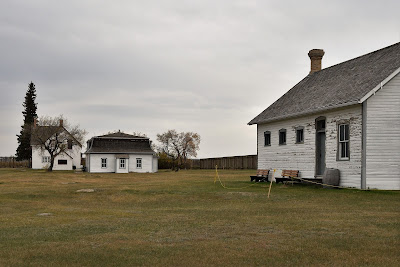
The Fort was closed when we visited, but we walked the grounds. The main buildings were enclosed in a tall wooden defensive barricade, which included barracks, the Officer's Quarters, the Commanding Officer's Quarters, and the guardhouse. The Fort changed over time as more space was needed, so some of the buildings were originals and others were added after the conflict of 1885.
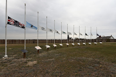
Outside the walls an arc of interpretive signs provided information on the history and accomplishments of the eight Indigenous Chiefs who fought in the Resistance and were hung in 1885. Above each sign flies the flag of the First Nation each Chief represented. It is a beautiful place, and it gave us a lot to think about. It feels like the revelations of this year have provided a chance for settlers and First Nations to redefine our relationships, and to finally move forward in new and better ways, but it isn't yet evident what this healing could look like.
After leaving Fort Battleford we made our way back to North Battleford, crossing the North Saskatchewan River on an old trestle bridge. It goes by way of Finlayson Island, which is a large treed island in the middle of the shallow river. It is covered in a network of winding footpaths, and although we didn't stop to explore, they seemed to be popular with dog walkers, joggers, and people out walking.
It has been a long day of exploring, and tomorrow we continue our indirect journey north-westward.
See you on the trail!
Remember to follow our entire adventure here : www.comewalkwithus.online


Comments
Post a Comment