Bonne Marche! : Sentier des Caps to Camp Liguoiri

From the rest area we followed an old paved road that is now closed to traffic for a few meters, and then ducked into the forest on a narrow winding footpath. As we made our way down the side of the valley we found ourselves surrounded by towering spruce, sweet smelling balsam firs, white birch, and alder. Sadly, yesterday's rain brought many of the deciduous leaves down, but they made a carpet on the mossy forest floor that seemed to glow brightly in the dim light.


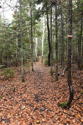
It was another enjoyable walk. Small boardwalks helped us across wet or uneven sections of pathway, and even though everything was soaked from yesterday's rain, they thankfully weren't slippery at all. The path was relatively level, easy to walk, and well marked, leaving us free to admire the colourful fall mushrooms, the water droplets that clung to the backs of fallen leaves and hung from the conifer needles, and the miniature green worlds growing up on the tops of mossy logs and rocks.


As we descended, the sounds of traffic faded into the distance, and we enjoyed a few moments of almost total silence. Apart from the honking of a White-breasted Nuthatch and the call and answer of a pair of Blue Jays all was silent. We stopped at a viewpoint with a nice wooden bench to enjoy the quiet beauty of the river valley, with its steep forested sides that towered above us.


Not too much farther along we began to hear the rushing of the Rivière de Salut somewhere down below us. We first crossed a wooden footbridge over a small stream that was bubbling and rushing merrily along its rocky bed, seemingly anxious to join the larger river below. Next, we followed a long, curving boardwalk that stepped gently upward through the golden leaves of the forest floor. As we descended towards the river again many of the trees we passed were adorned with long light green strands of Spanish moss, giving us the impression we were on some mythical and magical quest.


A bit farther along we came to a metal suspension bridge! We had some fun bouncing our way across it, but stopped to watch the rushing waters of the river below us, and enjoy the view down the forested valley. At the far side of the bridge we paused to take a short break at the conveniently located picnic table, and to enjoy the sights and sounds of the cold, crystal clear, fast moving water in the rocky streamed beside us.
The trail continued to wind through the forest, weaving up and down, passing large moss covered eskers, and taking us across several more footbridges and boardwalks. We crossed back over the river on a second very impressive suspension bridge, and then began to climb back up to the highway through the dense and fish smelling conifers.


As we made our way up we greatly appreciated the way the trails in this region have been built. The switchbacks are relatively wide, the trail bed is level, and often earth steps have been made which are even and of a good size for walking. On many of the steeper ascents larger stones have been placed on the pathway to act as natural steps. We offer our thanks and congratulations to the trail builders in this section for a job very well done!


When we reached the highway again we came to a trail head and parking lot. There was a rest area with a couple of picnic tables and a large painting of a lady's slipper. The painting was done on a glass panel, which reflected the needles and colourful leaves of the surrounding trees, creating a unique visual experience. Art in nature!

As we began the next section of trail we passed two ladies out for a Sunday morning hike, who smiled and wished us 'Bon marche!' as they passed. For the next 3 km we had a very easy walk along a crushed stone dust footpath that ran parallel to the highway. There was a lot of traffic, so we were very grateful for our treed corridor. Not only did we have a lovely footpath, but there was also a grassy track beside us, which we assume must have been for bicycles or ATVs. As we passed the Mômentum Refuges Nature, which is a very cool looking spot for glamping, the owner came out and asked us about our hike. Even with our very limited French, we've been treated with kindness by so many people here. It is a huge gift!


Eventually our pathway came to an end, and we turned onto the Chemin de Feif, which was a newly paved road. We followed the winding pavement down a forested hill, across a narrow wooden bridge, and then up to the trail head for the Gabrielle-Roy Ouest Trail. Beside the trail head was a welcome sign for Le Feif du Massif, which is a residential area and development that is adjacent to the ski center in Petite-Rivière-Saint-Françoise.


We began the 11.6 km trail around noon, and found ourselves on another gorgeous, forested footpath. A very short distance from the trail head we passed a large moss covered erratic beside which someone had hung a group of brightly coloured paper lanterns. It looked very festive and magical.


The walk through Gabrielle-Roy Ouest was very enjoyable, but it was largely uneventful. We walked through stands of dense conifers, across stretches where many of the trees seemed to have blown over, allowing a prickly understorey of blackberry bushes and ferns to grow up, along areas still bright with yellow leaves, and among stands of trees with nearly bare branches. Again we were shrouded in silence for long periods of time, although at one point the loud and demanding notes of a fog horn on a freighter in the Saint Lawrence Seaway rang out through the forest. At another point a pair of hawks chased each other at high speed above the trees, calling loudly as they went.


Around 2:30 pm we came to a sign at a fork in the trail in the middle of the forest for the Montagne à Liguori which had a small logo for the Sentier des Caps on it. There are two welcome centers for this next section of trail, but it isn't entirely clear to us from any of our maps where exactly the Sentier des Caps portion of the Sentier Transcanadien begins. Perhaps this inconspicuous place in the middle of the forest was the start.


The Sentier des Caps is over 50 km long, stretching from its starting point near the base of Montagne Liguori in the northeast to the top of Cap Tourmente in the south west. To get to the parking lot at the Cap TourmenteNational Wildlife Refuge there is an additional 7.7 km of trail with a very steep slope, and as far as we can tell the east end of the trail is accessed by walking part of the Gabrielle-Roy-Ouest Trail or the L'Ancestrale Trail. The main Welcome Center for the Sentier des Caps is near the west end of the trail, on the highway in Saint-Tite-des-Caps, and there is a second centre near the east end, in Le Massif that is open during the winter months. The trail is open for hiking in summer, and for snowshoeing and cross-country skiing in winter. For longer hikes, trail users must reserve campsites or refuges along the way, and it is possible to book luggage transport and/or food delivery through the trail group for a fee.


When we planned our hike along the Sentier des Caps we looked at the descriptions of the trail sections, which range from expert to suitable for beginners, and the changes in elevation, which reached nearly 800 m, and decided to reserve campsites based on the trail group's 5 day itinerary. We have no idea how well we'll do carrying full packs through the Laurentian Mountains, and we have memories of the Fundy Footpath, where the nature of the trail and the changes in elevation meant walking 10 km per day was enough for us.


As we begin this section of the Sentier Transcanadien we would like to send out a HUGE thank you to Linda from the Sentier des Caps information centre who was very friendly and incredibly patient with us, and helped us reserve everything by email using Google translate! We would also like to thank Margaret, Peter, Susan and others who have very generously donated to our hike in recent weeks and helped to cover the cost of our reservations on this trail section. Thank you all!


Shortly after reaching what we think was the beginning of the Sentier des Caps trail, the pathway abruptly became a bit more rocky and rugged, and it began to climb. We had reservations to camp at the Refuge Liguori tonight, which is near the top of Montagne Liguori at an elevation of 800 m. The map made it look like we had a long and very steep climb up to this point, but although it was indeed long, thankfully it wasn't too difficult. Again, we appreciated the work of the trail builders, who created a very pleasant trail with relaxing switchbacks that were easy to navigate as we ascended the rocky, mossy, and conifer blanketed mountain.


As we climbed Liguori we enjoyed several viewpoints with wooden platforms and benches that provided stunning views down the Saint Lawrence Seaway. Its blue waters stretched out below us, and we could see the ferry making trips back and forth to Isle-aux-Coudres. The sun came out for a short while, turning the rolling hills below us to gold. As we looked back along the shoreline we could see where Baie-Saint-Paul was situated, although most of it was hiding behind the hills.


Towards the end of our hike we saw a lot of other hikers on the trail, all heading in the other direction, except for one. Four or five couples passed us, as well as a larger group of five or six hikers. Our favourite was hearing a small child ahead of us on the trail joyously belting out a song at the top of his lungs as he walked. Sadly he stopped when he and his mother saw we were approaching.
In this area we were in part of a network trails for snowshoeing, skiing, hiking, and cycling, as well as access roads for the refuges, emergency access routes, and seemingly also access points to the town below and the nearby ski area. Happily for us, the routes were all extremely clearly marked with signs and maps, so it was very easy to navigate without getting lost.


We arrived at the Refuge Liguori around 4 pm, and quickly wished we'd made a reservation to stay in the wonderful looking wooden cabin, which had a wood stove, a sleeping loft, a picnic table, and a stunning view of the water below. Sadly we were just too late to change our reservation before the trail center closed, so we headed back up to the flat grassy camping spot at the edge of the trail and pitched our tent.


We had been under the impression that there was a water source about 1 km down the trail from the Liguori Refuge, but we were mistaken (as the map clearly warned). After going to investigate but finding no stream, we decided against making dinner, since between us we only have about 1.5 litres of water, and we'll have another 7 km to go tomorrow before we come to the next water source. We had some of our breakfast bread with jam, but it left us feeling pretty hungry and thirsty. Aside from that small disaster, it was a pretty wonderful day, and it left us feeling much more confident about the next few days on this trail. As we listen to the wind in the trees and the sounds of Snow Geese flying overhead, we feel truly blessed to be out here.
See you on the trail!
Remember to follow our entire adventure here : www.comewalkwithus.online
Comments
Post a Comment