Leave No Trace : Across the Qu'Appelle Valley
The scene which greeted us this morning when we looked out of the tent was one which reminded us of why we are doing this hike. The sun was rising at the end of the Qu'Appelle Valley, turning the river into a silver ribbon below a soft pink sky, and giving the folded hills on the valley edges texture and dimension.
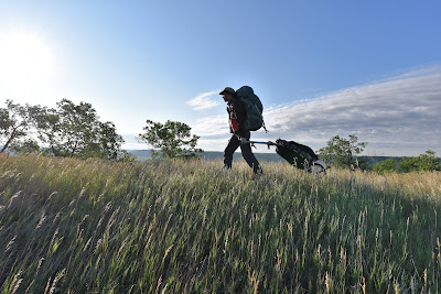
We made our coffee and bagels, packed up, and set off, making many stops along the lip of the valley to admire the view stretching out before us. We made our way down to the bottom of the valley on a narrow, winding, gravel road that switch backed around steep dunes of forest-covered sand and silt. The view on the way down was spectacular.
About 14,000 years ago the edge of the continental ice sheet stalled over what is now southern Saskatchewan. As the climate gradually warmed, the ice began to melt. The melt-water originally flowed south, following the course of the Souris River, until the land underneath developed a northward tilt. The water then began to follow a course running eastward, parallel to the ice front. In the process it carved out a channel that is 152 km deep and 400 km long, which we now call the Qu'Appelle Valley.
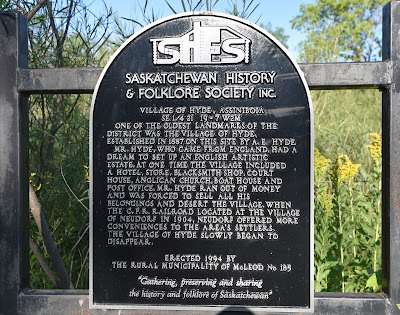
When we reached the valley floor we found a historic plaque for the town of Hyde. This village was established in 1887 by A. E. Hyde, who arrived from England. At one time the village included a hotel, store, blacksmith, court, and post office. At one point Mr. Hyde ran out of money and had to leave the village. In 1904 the C.P. Railway arrived in Neudorf, and the village of Hyde slowly began to disappear as it inhabitants were drawn to the many conveniences Neudorf offered. Today the only sign of the town was the historic plaque and the remains of an orchard.
A few steps beyond the historical plaque we came to an upsetting scene. Someone had recently camped here on the side of the roadway and in the process had made a makeshift fire by burning dried branches. There were no rocks around the scorch mark on the ground, the blackened circle was still smouldering and was warm to the touch. Here we stood in the middle of a drought, just a few feet away from fields of dried crops, expensive farming equipment, as well as people's houses yet someone had not only started a campfire but not put it out! Making matters worse there was a pile of plastic water bottles sitting in a heap. Furious Sean soaked the ground with half of our available filtered water and collected the garbage. This year while trekking we have not even used our MSR camp stove and fuel given the heat conditions and potential to spark a fire yet here someone had set a fire headless of the possibilities and dangers. Beyond the inherent dangers of having an open fire at the moment, not respecting the situation nor following Leave No Trace principles by leaving garbage on a site only serves to make it less likely that future hikers and trail users will be welcomed. All who use trails must remember that so much relies upon the kindness of local residents who allow the public access but who only do so as long as we all leave the area in good order. Hiking, Cycling, Trekking, and Camping necessitates that we are all responsible in our ventures. Having cleaned up the site as best as we could and as we continued on an old adage came to mind : Leave only footprints, take only pictures!
Slightly down the road we came to the double arched concrete bridge we'd seen from our campsite, which spanned the Qu'Appelle River. We could see the ruffled blue waters of the small river winding off into the distance, its banks bordered by grass and the occasional patch of cattails. Although we walked the valley all day, this was one of the few times we actually saw the river.
As we made our way along the valley bottom we passed many small farms. When we first descended into the valley we passed fields of grain, some of which were being irrigated with large sprinklers. A bit later on we passed fields of grain interspersed with hay, and a few patches of corn, which is a crop we haven't seen much of lately. By early afternoon we were passing more and more pastures, many dotted with cows and a few filled with elegant, curious, horses.
There was lots of activity in the valley today, with many farmers out mowing their hay and alfalfa, and harvesting their wheat. Some fields were already dotted with spun hay bales, while others were covered in sharp golden stubble with rows of feathery grain on top, sparkling and shining in the bright afternoon sun. Other fields were still uncut, and some made lush patches of green.
As we walked we noticed that to the south the steep sides of the valley were covered in trees, but on the north side the sandy folds of the valley wall were covered in short, dry, grass. This is because the southern slopes are somewhat sheltered from the harsh prairie sun, and less moisture evaporates. On the north side deep rooted grasses that are adapted to the baking soil thrive, whereas small trees and shrubs only inhabit the more sheltered coulees between the folds.
We spotted Western Meadowlarks in a few of the hay fields, which is a species we haven't seen in a few weeks. We also spotted a Black-billed Magpie, which is another colourful favourite we've been missing. Black-capped Chickadees, Warbling Vireos, Yellow Warblers, and Red-eyed Vireos called from the forested slopes, while Mourning Doves cooed, American Crows called, and mixed flocks of blackbirds swirled and dove. Overhead Turkey Vultures soared majestically along the valley edges, riding the updrafts. Every so often we would hear the iconic shriek of a Red-railed Hawk, and in the afternoon a majestic Bald Eagle soared down the length of the valley.
From the map we had assumed that we would be following a flat, level road along the bottom of the valley. Instead, we found ourselves tracing the edge of the hills on an undulating road that wove up and down along their folds. Sometimes we would circumvent large conical hills, or sand dunes, being momentarily cut off from the rest of the valley. It was an incredible landscape, unlike anything we'd seen before. If you ever have the opportunity this is certainly a landscape that everyone should take the chance to venture through and enjoy!
Around noon the wind began to rise again, drowning out the crunching of our boots and wheels on the gravel road, and the high pitched chirping of the crickets. It pushed the soft fluffy white clouds across the blue sky, causing their shadows to race each other across the patchwork of green, brown, and golden fields below. The movement seemed to bring the valley to life.
In addition to colourful fields, there were also striking red wooden barns and weather beaten grey sheds, telling the tale of what came before for those who knew how to read it.
By late afternoon we came to the tiny, historic village of Ellisboro. In the 1870's the crossing of the Qu'Appelle River at this spot was known as Racette's Crossing, being named after a local servant of the Hudson's Bay Company. It was an important crossing because it was located on the Carleton Trail, which connected the Red River Settlement to Fort Carleton.
See you on the trail!
Remember to follow our entire adventure here : www.comewalkwithus.online


Comments
Post a Comment