Inaccessible Trails : Duck Mountain PP to Kamsack
This morning began around 5:00 am when a flock of American Crows decided to give the morning an incredibly long and loud welcome from the conifers above our tent. This seemed to inspire the Common Loons on Madge Lake to join in with a beautiful, haunting, complex, and high volume duet. Nature is wonderful, but sometimes it can be very noisy!
As we packed up we chatted with our neighbour, who was interested in our carts, and seemed enthusiastic about our hike. Since reaching Saskatchewan a lot of friendly people have approached us to chat, which we've really enjoyed. We headed back down to the beach and took a few moments to enjoy the still, quiet, peaceful waters of Madge Lake in the soft morning light. We spotted the Common Loons, as well as several Red-necked Grebe families paddling among the grasses.
As we made our way back up to the trail we passed the Park Office, and then followed a lovely forested path through a small stand of trees, back to the water. There we crossed an inlet on an cool footbridge with a wavy wooden deck and blue railings at the end of a marina.
The next stretch of trail took us down a treed lakefront road running parallel to Madge Lake, which had boat docks on one side and cottages on the other. There was a mix of large, modern, glass-fronted cottages, and smaller wooden cabins that reminded us of the much-loved cottages of our youth. Many of the vacation homes were beautifully landscaped and featured artistic decorations or creative features. In addition, there were blow-up unicorns, paddle boards, kayaks, and boats at many of the docks, suggesting a level of affluence and a sense of joy and fun we haven't seen a lot of recently.
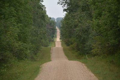
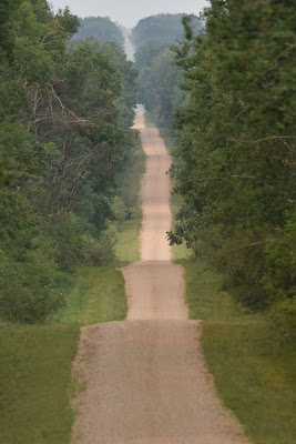
Eventually the cottages gave way to an undulating gravel road that was bordered by very tall trembling aspens, their straight white trunks forming a wall on either side of the road. We passed several trail heads for hikers and a few well-marked snowmobile trails. Through gaps in the roadside trees and shrubs we caught glimpses of marshes and lakes, the trees almost perfectly reflected in their still surfaces. At one marsh we spotted five families of Wood Ducks, a pair of Blue-winged Teals, and a couple Buffleheads.
As we continued on down the road we heard the melancholy mooing of cows in the
distance, and slowly the marshes and lakes gave way to hay fields on either
side of the forested concession. At one point we were passed by a truck
going to collect hay bales in a field just beyond our treed corridor, but
otherwise we had the shady undulating country road to ourselves.
At one point the Trans Canada Trail markers directed us off the nice gravel road, and we followed the ups and downs of a secondary track among marshes, hay fields, and stands of trees. Soon after we stopped to watch a family of Northern Flickers whining and chasing each other up and down among the aspens. A Song Sparrow called nearby along with a Red-eyed Vireo, and a flock of Black-capped Chickadees chatted companionably in a nearby shrub. As we paused to listen, a pickup truck passed us on the narrow track with three small children in the front, all of whom gave us huge smiles and enthusiastic waves.
Shortly after this we ran into some difficulties. We turned east down a grassy track and followed it about half way down the concession. There were a few fallen trees across it, but we had faith in it, right up until the point where it ended. A 'No Trespassing' sign and a gate blocked the track where it turned into a field, heading in the wrong direction. In front of us, where the map suggested we could continue straight to the next concession, was a huge pile of cleared trees, and no more trail. We searched around a bit, but there was simply no moving forward, which is what we'd seen on the map Erlen Dur shared from his cycling trip across Canada.
We had no choice but to turn around, and after backtracking for half a concession to turn west instead. We boxed around and walked south to the highway, hoping to pick up the trail again. When we got to the point where the trail was supposed to pick up we found no markers, and no sign of the path we were supposed to take. Perhaps we weren't in the correct spot, but it seemed the trail's connection was broken in this area, and/or didn't line up with the map. According to the App we were supposed to walk south of highway 57 and box up and down through the community of Coté before heading west towards Kamsack. After boxing south, east, and west, we'd added just under 10 km trying to re-find the trail, but without success. We again boxed around the local concessions adding kilometre after kilometre and only found more 'no trespassing' signs but no Trans Canada Trail. As it was nearly noon, getting oppressively hot, and given that we had now ventured almost 15 km trying to find the TCT we decided to backtrack to one concession north of the highway and simply head straight west towards to Kamsack completing what was due to be a 42 km day.
Each time we cross into a new province our minds look for signs of changes and differences. It's difficult to describe, but we feel like we're suddenly in a different place. In parts of southern Manitoba, especially around Emerson, we walked through very flat, intensively managed agricultural land, but somehow the landscape here in Saskatchewan has a different feel. Perhaps we're just imagining it, or maybe as we make our way through Saskatchewan we'll come to understand it's uniqueness.
We followed a straight gravel road that was level with the canola and grain fields on either side. There were no signs or sounds of birds, only the chirping of crickets and the buzzing of flies. The crops were planted right up to the edges of the deep, white gravel we were ploughing through with the carts. When pickup trucks passed us, we had to step between the first rows of the crops to move out of the narrow roadway. All the drivers smiled and waved as they passed, which was encouraging.
When we were 14 km from Kamsack we could already see it ahead of us, in the middle distance. As we walked towards it we were passing south of the Coté Indian Reserve 64, which is home to the Coté First Nation. This Saulteaux reserve is connected to the Keeseekoose First Nation, and is only a couple miles away from the Key First Nation. The Ojibwe of this region were traditionally hunters and fishermen, living off the abundant lakes and waterways of the area, and hunting in the Boreal forest, as well as for plains bison. When the bison were nearly brought to extinction by commercial hunting in the 1870's the Ojibwe began to suffer from famine and they lost their way of life.
On September 15, 1874 Coté Chief MīMīY signed Treaty 4 at Fort Qu'Appelle, North-West Territories. This was an agreement between Queen Victoria and the Cree and Saulteaux First Nation band governments, which covered an area extending through most of southern Saskatchewan and parts of southwestern Manitoba and southeastern Alberta.
The numbered treaties were signed after the Hudson's Bay Company sold Rupert's Land, which extended from the Rocky Mountains to the Great Lakes, for £300,000 to the Dominion of Canada in 1870. The Indigenous peoples whose traditional territories were sold in this transaction were not included in these land transfer negotiations, leading them to seek recognition and protection through their own agreements, which became the numbered treaties.
When we reached Kamsack we took some time to explore the town. It is a beautifully landscaped community, with a garden recognizing the contributions of its senior citizens, a central park with a war memorial dedicated to non-Indigenous and Indigenous soldiers from the three First Nations in the area who served in WWI, WWII, and all conflicts since.
At the far edge of town we visited the beautiful Trackside Gardens, which were located right beside the railway tracks, and featured a stone pathway that wound among large and colourful flower gardens, a bench made using old train wheels, and a beautifully restored CN car. Although the Trans Canada Trail doesn't actually come right into the community of Kamsack, there was also a TCT pavilion in the small park - our first in Saskatchewan! We were heartened to see that the park and its surroundings were created and maintained by volunteers from the community.
See you on the trail!
Remember to follow our entire adventure here : www.comewalkwithus.online


Comments
Post a Comment