After
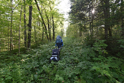
two days of pushing our way through this landscape we emerged mosquito
bitten, mud covered, and tired on the edge of a subdivision near Doe
Lake. Here our way forward became unclear, as the trail markers (on
metal posts) veered into the nearby marshland and the route of the path
was disrupted by housing development. The result being that we had to
briefly leave the trail and move onto the unshaded local roadways which
would in turn lead us to the exclusive cottage resort town of
Gravenhurst.




Concerned
that we had missed the correct route after leaving Washago, we reached
out to other Trans Canada hikers, only to have our experiences confirmed
by their own. However, after posting about our assessment of the
pathway we received a number of very direct messages and emails
suggesting that our account was entirely inaccurate. Several regional
hikers insisted that the route was clear and easy to follow. One
individual insisted that they trekked the entire 40 km stretch several
times a week with no difficulties. All I can say in response, is that
we were either woefully out of shape, wildly lost, that there is another
pathway that everyone else takes, or there is some confusion as to
where the Great Trail is throughout this region as there was scant
evident that anyone had recently ventured the length of this portion of
trail from Copper Falls to Doe Lake.


In
retrospect, this stretch of trail served as an indicator for what was
coming on many portions of the Trans Canada Trail through the Muskoka
region. Time and again as we navigated across the Muskokas and Northern
Ontario we would find that trail blazed pathways in fact went directly
across extensive marshes or through / over deep regional lakes. Our
sense then was that much of this region is meant to be used as
snowmobile trails rather than hiking or cycling paths. This would
explain why so many marked routes turned into wetlands, why these
regions are often gated, and why even the TGT app suggests one hike
directly across lakes. Regardless there is little denying that the
natural beauty throughout the area is incredible, and that one's
appreciation for it only increases once you have expended such a huge
effort to reach it.


Moving
on, despite the heat of the season, our trekking days got longer – both
in terms of hours spent on the trail and kilometers covered. Having
entered the Muskoka region after a month of predominantly sidewalk and
road trekking we had hoped for sheltered pathways and nature trails.
Despairingly however the TGT from Granvehurst to Bracebridge, despite
traversing such beautiful landscapes primarily followed busy regional
roadways through affluent neighbourhoods and past exclusive golf
courses.
Arriving
into the town of Bracebridge the trail traced between the local
community park and water purification plant. This meant that despite
the late hour and being exhausted from the heat we spent almost an hour
navigating the flooded and rough trails around the water ponds while
birding!
Continuing
on, the Great Trail joined with the local roadways tracing the banks of
the Northern Branch of the Muskoka River. Unfortunately the local
campgrounds were closed to overnight campers in tents and so we again
spent the night in the local Quality Inn which turned out to be both
very busy and a very expensive place to lodge.
From
Bracebridge to Huntsville, a long stretch of path that we covered in a
single day, the trail alternated between road walking, crossing small
hydro dams, venturing down forestry tracts, through chest deep washouts
and waste deep marshes, to navigating logging cuts and trekking rural
concessions.
Perhaps
most difficult was the fact that throughout large portions of this
section it was not possible to refill our water bottles and hard to find
a place to sit and relax as most of the region was fenced and signed
private property. Once again while challenging, the natural rewards
throughout this area were amazing and included sightings of moose, fox,
rabbits and countless birds.
Despite
the late hour, our arrival into the majestic town of Huntsville was
noted by the local digital librarian who was kind enough to stop, talk,
and post about our trek online! In town, we were very dirty, soaked in
sweat, and dishevelled – once again. With few options we checked into a
local establishment, enjoyed a long shower (perhaps two or three
showers), laundered our clothes (several times) and took a day to catch
up on our blogs as well as resupply.



Comfortable,
and disinclined to hike a long distance into the blazing heat of the
day we decided to trek the tails of the city of Huntsville. Here the
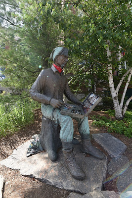
city pathways wove through the beautiful downtown, past the iconic Tommy
Thompson statue in front of City Hall, to Kawartha Dairy for…..large
ice creams…..before continuing on to our campsite for the evening. En
route the trail wove along neighbourhood sidewalks, through active
construction sites, around road work, and circumvented a number of local
golf courses. Our goal for the night had originally been Arrowhead
Provincial Park, however when we arrived it turned out that they were
completely reserved for the better part of the summer. Fortunately we
were welcomed and helped by the kind staff at the nearby and impeccably
clean as well as friendly Lagoon Tent and Trailer Park!


With
slightly cooler weather and more shade than we had seen since Eastern
Ontario we continued onward venturing onto the Park to Park Trail, a
multi-use pathway that brought back memories of the wilderness,
relaxation, and freedom of the back-country in Newfoundland! Here the
trail was a wide gravel and dirt track that wove alongside lakes,
rivers, and wetlands. While ATV use is allowed, everyone we met was
kind enough to slow down, chat, and offer aid.
At
one point the Park2Park trail changed into the Seguin Recreational
Trail which was developed on the rail bed of the former Grand Trunk
Railway, historically used to move regional lumber to the Ottawa River.
Throughout this entire stretch, the wonderful conditions that we had
enjoyed on the Park2Park Trail continued as we traversed through the
quiet communities of Sprucedale, Whitehall and Seguin Falls.
Here
on the shores of Lower Fry Lake we picked up the Old Nipissing Road
Connector, also mysteriously known as the Ontario Ghost Trail, on which
we would trek northward. The Old Nipissing Road Connector ventures
through a landscape which was home to regional pioneers, historic
forestry operations, and weathered farms. For a time this route served
as one tract in a network of colonization roads established by the
pre-confederation government in the 1850s.


While
a few stretches throughout this area are paved, the majority of this
way is either a gravel or dirt trail utilized by 4x4 vehicles, ATVs,
snowmobiles, cyclists or hikers. Throughout this region our days were
again spent on quiet trails, enjoying wild camping, loving the landscape
and luxuriating along the clear lakes of Ontario. So much of what we
fund here is what we had been waiting to return to for so long! We were
back on a stretch of nature in which our greatest challenge was
navigating the few trail washouts and ruts in the sandy pathway. At
least for a few days the glorious fresh air and forests of the Muskokas
were entirely ours!


After
a few days of trekking we came upon the wonderful, welcoming and quirky
shop – The Cornball Store! There are a few places that are recommended
to us as we trek, and fewer still that are recommended by so many
people – the Cornball Store was just such a place! Having arrived we
dropped our backpacks in the shade, entered, receiving a warm welcome,
and proceeded to get a couple of cold ice creams, refill our water, and
pick up a few amazing baked treats. When we went to pay, it turned out
that a local supporter had already made arrangements to have our bill
covered – we were once again being cared for by distant Trail Angels!
Thankful, we rested outside in the shade of a nearby tree, to the
curiosity of the numerous customers popping in for treats.
Venturing
on, now sadly back on a long exposed roadway, we began our approach
toward the community of Magnetawan. Before getting to town however we
would spend an evening with Alex and his amazing family, who had offered
one of their unused family cottages to us for the evening! Alex, is an
amazing former university colleague for whom I was a Teaching Assistant
in Ornithology while completing my graduate work at the University of Toronto. It was with great excitement that we turned off the trail amid
the summer heat and found our way to his cottage! We arrived to find
wonderful kindness and support. Here we were able to launder our
clothes, dry out our soaked gear, catch up on our writing, swim in the
lake, and best of all enjoy an evening chatting and having a home cooked
meal!




After
an amazing night’s rest and a fabulous breakfast we returned to the
Great Trail and soon arrived into the welcoming community of
Magnetawan! On the edge of town we met up with Barbara, who gave us an
excited and warm welcome! She also provided us with a firsthand tour of
the town site to the iconic St. George’s Anglican Church the focus of
A.J.Casson’s famous Group of Seven painting of the region, to the
beautiful Magnetawan Locks and along the Dam Trail.
In
town, owing to Barbara’s amazing efforts we also enjoyed the
opportunity to chat with local residents, meet with journalists from The Great North Arrow as well as the town mayor, the gracious Sam Dunnett and his lovely wife. Here we were presented with a complimentary Magnetawan T-Shirt
(that we intend to carry with us on our travels to the arctic). As we
said our goodbyes we made one final stop to the beautiful local market
on the edge of town where we resupplied with far too many local baked
treats for our hike!
Continuing
along the Old Nipissing Road Connector on an ever narrowing former
logging road our route took us through beautiful forests where we could
explore, relax and bird without interruption! Northbound the way wove
through unique locations such as the historic community of Bummer’s
Roost whose origins are a subject of debate, but whose name is certainly
memorable!


The
trail, a sandy and uneven track, next boxed around the end of the
beautiful Deer Lake, touring along ATV and snowmobile routes into the
rapidly developing cottage country to the rural community of Commanda
prior to returning to an affluent cottage subdivision around Wolfe
Creek. Again venturing along county roadways our days became hot and
dusty with most of our energy focused on seeking shade and water. It
was on these roadways that we pushed into the community of Nipissing,
where we were graciously helped by the kind staff at Foote’s General
Store and where we took the chance rest, buy ice creams and have a few
cold drinks!


With
night settling in, exhausted from several humid and long days on the
trail (and presently surrounded by only private property) we decided to
venture some 5-7 km off the path to a local campground to rest and have a
cold shower. Ultimately this would prove a harsh mistake. Having
called, confirmed availability and made reservations, we made way to the
campground on foot - our 10th hour of hiking for the day. Arriving an
hour later we got to the campground which despite assurances had no
running water, no showers, and no washrooms for day campers.
Frustrated, in tears, and still in our hiking clothes, we left just
after midnight after not being able to make dinner and amid a violent
downpour. However as the saying goes “a bad night on the trail is still
better than the best day in the office”. There was no denying however,
that this evening certainly put that axiom to the test. On the bright
side we were now cooled off and all of our clothing as well as gear had
been naturally washed thanks to mother nature.


Squishing
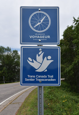
onward, along the Great Trail, we sadly returned to concession and road
trekking. The sole exception to this being the Callander Trail which
is described online as a 9-10 km section through the region’s natural
landscape crossing farmlands and wetlands where muddy conditions should
be expected. In reality much of this stretch was a route through
wetlands and is clearly meant to be a snowmobile trail rather than
hiking or cycling path undertaken in the frozen conditions of winter.
Further soaked and muddied, we soon diverted out of the mire of the
local marshes which we found to be challenging on foot and made our way
back onto the nearby roadways.


Exhausted
and struggling through the seasonal heat we followed the trail as it
made its way through neighbourhood streets and onto the startlingly busy
regional highway. After an ice cream break in the town of Callander we
continued hiking along the paved, accessible, and wonderfully shaded
Kate Pace Way into the heart of North Bay – the Gate Way to the North.
In
town, and unable to find camping, we again checked into a motel and
decided to take a few days to rest, resupply and plan the 575 km hike to
Sault Ste Marie. In North Bay we explored the harbour front, visited
the house of the famed Dionne Quintuplets, and strolled through the
forested campus of Nippising University. While visiting we were amazing
at how supportive and kind the residents of the region were to us.
As
we stood in North Bay prepared to move on into Northern Ontario our
hike was due to shift yet again - as much of the coming 500-700 km of
trail would be on busy roadways and the Trans Canada Highway prior to
reaching a 1000km water route through Lake Superior. Needless to say,
after almost 1500 km of trekking since leaving Ottawa we were at long
last set to venture westward again!
See you on the trail!
Remember to follow our entire adventure here : www.comewalkwithus.online




Comments
Post a Comment