Achievement and Humility : into Montreal
"Sometimes, at the height of our revelries, when our joy is at its zenith,
when all is most right with the world; the most unthinkable disasters descend upon us."
This morning began not with the tranquil sounds of birdsong, wind in the leaves, or a nearby river, but with the roar of traffic and the sound of sirens outside the window. Leaving the trail each winter is always a difficult transition, and the sounds of civilization did little to entice us back to the world of condo-sitting, a full-time desk job, the next round of applying for sponsorship and funding to replace our gear, and planning for next year. Our lives are now divided between time on the trail and time spent preparing to get back onto it, and the former is by far our preferred state of being.
Given that we had only 20 km to go to our destination and the conclusion of this year’s trek we needed to time our arrival at yet another hotel which would not allow us in until 4 pm ... so there was no need to rush. As such, though we were awake at 4 am and our bodies wanted to go, we waited and enjoyed a late breakfast not leaving until 10 am. The fact is, at the moment, our days were no longer to be dictated by distances, camping sites, or points of interest, but instead are determined by the schedule of urban centres. From this perspective the backwoods of Newfoundland, coastlines of the maritime provinces, ruggedness of Northern Ontario and freedom of the open spaces in the prairies are now very far away.

When we left our hotel we walked back through the busy neighbourhood where people were heading out to work and school, crossed back over the highway, which was filled with bumper-to-bumper morning rush hour traffic, and continued our walk south along the shores of the Saint Lawrence River. The Port of Montreal looked much closer in the early morning sunshine than it had yesterday evening, and the Olympic Stadium appeared to be nearly twice as big as it was yesterday. It is always interesting how perspective and lighting can change our perception of landscapes.
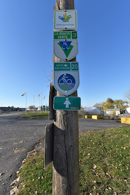

We followed the paved cycling trail along the shoreline, walking under stands of mature maples that were still adorned with brilliant red and yellow foliage which positively shone in the late fall sunshine. Trekking the curving trails of the Parc Marie-Victorin was like walking in a glowing tunnel, but the crunching of the leaves under our feet was mostly drowned out by the noise of the highway beside us.


We passed the marina, with its many boats tightly shrink wrapped in white plastic to protect them against winter's ferocity. As we passed the Yacht Club we could see the curving steel arcs of the Jacques Cartier bridge which spans the Saint Lawrence River, connecting Longueuil to the Island of Montreal, and providing access to Île Sainte-Hélène in the middle of the waterway ahead of us. It is one of eight bridges that connect the island of Montreal to the mainland.

We could also see the blue, yellow, and orange curves of the roller coaster in La Ronde amusement park across the water, which was built as the entertainment complex for Expo '67, the 1967 World's Fair in Montreal. La Ronde is Québec's largest amusement park, featuring a range of rides, including the world's highest double wooden roller coaster and a smaller corkscrew roller coaster.

The paved bicycling trail took us under the Jacques Cartier bridge, and continued along the water's edge for another few kilometres. Along the path were signs with a Highway H20 logo in the corner, which provided (likely useless) but interesting factoids about the cargo and ships that pass through the canals and seaway and the Port of Montreal which appealed to our geekish natures. For example, one sign informed us that one full size laker supplies enough wheat to make a string of bread loaves that could stretch from Halifax, NS to Victoria, BC 2.5 times! How cool is that?


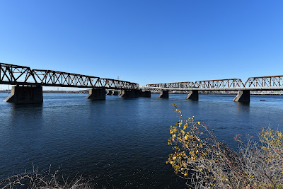
Eventually we came to a cluster of interwoven bridges that converged in an interesting way at the Saint Lambert Lock. The largest and most prominent was the Le Pont Tubulaire Victoria. When it was constructed between 1854 and 1860, the 2,009 m tubular bridge was recognized around the world as an outstanding engineering achievement. With the help of new types of steam-powered pumps, cranes, and derricks Canadian engineers and contractors were able to overcome previously insurmountable construction challenges, and the presence of the original concrete piers is a lasting testament to their achievement. The bridge was based on a British design and erected by the Grand Trunk Railway, and it became a vital link in the nation's railway network.
As we approached the Saint Lambert Lock a barricade was being lowered, and the section of trail ahead of us was raised high above our heads to let the cargo ship Rosaire A. Desgagnes pass through underneath, making a 15 ft change in elevation inside the lock. We waited patiently for the large ship to pass through the narrow channel, enjoying the amazement and exuberant curiosity expressed by a very small boy who was also waiting to cross with his father.
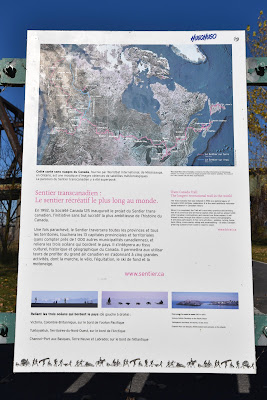


About 15 minutes later we were able to cross the water onto Île Notre Dame, where we found a Sentier Transcanadien map and sign. We stopped to take a photo in the bright morning light, marking our arrival into the final city we will walk to this season. Although exhaustion is beginning to weigh heavily, the weight loss is evident, and our clothing is near to transparent – we couldn't help but feeling the excitement of being so close to our end point for this year.

We continued down the quiet treed streets and cycling paths of the island, which together with Île Sainte Hélène makes up Parc Jean-Drapeau. Île Notre Dame was built for Expo '67 over a 10 month period from rock excavated during construction of the Montreal Metro in 1965. Many of the pavilions for Expo '67 were demolished in 1975 to make way for a long rowing and canoeing basin for Montreal's 1976 Summer Olympics, and it is still North America's largest artificial rowing basin.


As we crossed the quiet island, which felt like a cross between Toronto Island and a closed amusement park, we also passed the large, rounded Montreal Casino. Today it was topped with a ring of orange flags to honour Indigenous survivors of Residential Schools.

At the western end of the island we passed a small lake with a sandy beach. During the summer it is open for swimming, volleyball, and watercraft rentals, but it was mostly deserted on this warm November afternoon.


As we made our way from one island to the next we walked through the Jardins des Floriales which was created in 1980 for an international horticultural exhibition and competition. Plant species from dozens of countries around the world were brought together in a 25 ha area and used to create a series of gardens, each with a unique character representative of different countries around the world.

We stopped for a few minutes to enjoy the wooden pavilions, small bridges, winding pathways, and tiny lagoons of several gardens, all of which were accented with brilliant fall colours. From a distance we were drawn to a garden that was dominated by incredibly tall white pines, and seemed to have a slightly wilder feel. We were amused to discover that this was in fact the 'Canada Garden' which likely explained why we felt at home there.


Although le Grand Sentier turned onto the Concorde Bridge, taking a more direct route onto the Island of Montreal, we decided to do a short walk around Île Sainte-Hélène before following it into town. It was a warm, sunny morning, we couldn't check into our hotel until 4 pm anyway, and as sometimes happens at the end of long-distance hike, we found ourselves wanting to make those final moments last as long as possible.

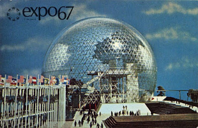
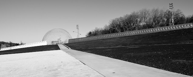
Walking around this island, we also had a chance to see some of the most iconic landmarks of the Montreal skyline up close. One of these was Buckminster Fuller's geodesic dome, which originally served as the United States Pavilion for Expo 67. This huge dome, which is now referred to as the Montreal Biosphere, now houses an interactive nature museum dedicated to showcasing the water ecosystems of the Great-Lakes Saint Lawrence region. The museum is housed in a set of buildings designed by Eric Gauthier that are located inside the original steel skeleton of the geodesic dome, and they feature exhibits on environmental issues related to water, climate change, air, ecotechnologies, and sustainable development.


We didn't visit the inside of the museum with our full backpacks, but we paused for a while in the huge, open, concourse at the base of the dome, which is known as Espace 67. The space is closed to motorized vehicles, and features benches, small trees, small art exhibits, and interpretive signage for pedestrians throughout. On this sunny morning there were quite a few other tourists out in the square, also looking up at the impressive dome above us.
Not far from the dome, on the other side of the open plaza was the Stewart Museum, which was housed in the old Arsenal British Garrison, where troops were stationed in the 19th century. The museum showcased the influence of European civilization in New France and North America, displaying items that featured developments in politics, science, and culture over the last five centuries. It is now permanently closed to the public, but still offers some virtual programming. There was something surreal about seeing the old red brick building, which clearly belonged in a different century, next to the gigantic dome, and the other modern glass and metal buildings that lined the square.

As we made our way towards the river we came to a huge metal modern art sculpture. For me it vaguely brought to mind some kind of abstract insect poised on the water's edge, and I was momentarily confused to discover that it was called 'Trois disques sculpture. L'homme.' It seems the reference wasn't to what it represents, but rather was a tribute to the theme of Expo 67, which was 'Man and His World.' Realizing how unacceptable that theme sounds today gives me some encouragement that we have made at least a little progress over the past 40-some years. In any event, the sculpture was created by American sculptor Alexander Calder, it is one of the largest sculptures of the 20th century, and it is considered one of the most important pieces of public art in Montreal.

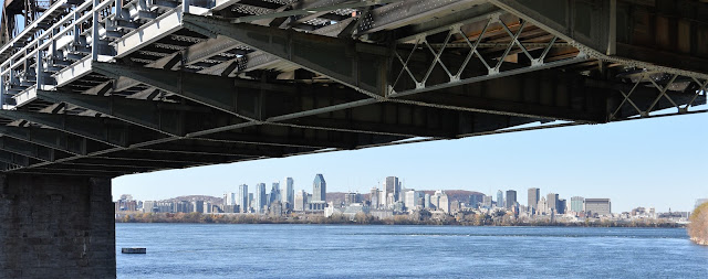
Standing down by the water near the sculpture we had a magnificent view of the Montreal skyline. We could see banks of tall glass towers rising up like a forest on the shore, the white circle of La Grande Rue de Montreal Ferris wheel in front of them, and what we assume was the dark shape of Mount Royal sitting solidly in the background. The most widely accepted origin of the name 'Montreal' is that it comes from this small mountain, which is part of the Monteregian Hills and is now located inside the city.
While the view was stunning, and it was easy to see why so many music festivals are held on the Île Sainte-Hélène during the summer months, there was a very strong and cold wind blowing right down on the water, prompting us to move along.

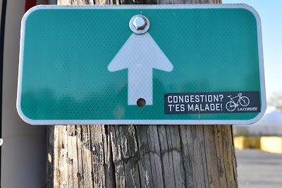
We made our way back across the pleasant, calm, treed island to the Concorde Bridge. After all the obstacles we've had to overcome this year in order to keep moving forward, it seemed almost fitting to find a 'Route Barée' sign, and extensive construction on the bridge. However, to give the Route Verte it's proper due, it didn't let us down and leave us to navigate a long detour on our own, but rather provided a well-marked and easily navigable route through the construction. If only the going were this easy across all of Canada!


On the far side of the bridge we found ourselves on a long spit of land known as Dieppe Parc. Here we found another iconic reminder of Expo 67.

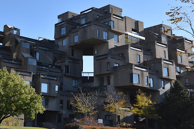
Habitat 67 is a model community and modular housing complex designed by Israeli-Canadian architect Moshe Safdie. The design process began as Safdie's Master's thesis project in the School of Architecture at McGill University, and it was originally built as one of the pavilions for Expo 67. It is now considered one of the most recognizable architectural landmarks in both Montreal and Canada.

The unique building is comprised of 354 identical, prefabricated concrete forms that are arranged in various combinations. There are many open spaces between the units, which are stacked up to 12 floors high in some areas. The building now houses 146 apartments which range in size from 1-8 units, each of which has at least one outside terrace. The idea was to integrate the benefits of suburban homes, like gardens, fresh air, privacy, and multi-leveled environments with the economics and density of apartment or condo living.
This intriguing building captured our imaginations as we made our way along the sidewalk, until we were momentarily distracted by the sight of several people walking past in wetsuits and carrying surf boards. This struck us as a strange sight in the city, but apparently the nearby Parc des Rapides features a permanent wave formed by natural water flow through the rapids, known as 'Guy's Wave,' which attracts surfers, kayaker, and paddle-borders to the area. Who would have guessed – surfers in Montreal! My father, a lifelong windsurfer and adventurer, would have loved it.
As we made our way down Dieppe Parc we found ourselves walking past a modern working port, and enjoying a view of the Old Port of Montreal. This 2 km long district is part of historic Montreal, and is adjacent to Old Montreal. It was used as a trading post as early as 1611 by French fur traders. In the 1990's the Old Port was redeveloped and is now a recreational and tourist district that attracts over 6 million visitors a year.


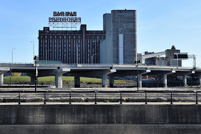
To reach the restored part of the historic Old Port we first walked around a very busy and active shipping terminal, under the highway, and past a group of old warehouses and grain silos belonging to Five Roses Flour, the Canada Malting Co., and others. The colour, texture, and geometry of the old red brick, dusty glass, iron, and rusted metal of the old industrial buildings were an urban photographer's dream. However, by this point we were too excited by an upcoming milestone to linger too long.


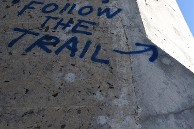
We paused to investigate some interesting street art painted under the bridge, which showcased scenes of historic importance from the area. When we emerged onto the far side of the underpass we found ourselves at the edge of the Lachine Canal, which was drained of most of its water. This 14.5 km long canal connects the Old Port of Montreal to Lake Saint-Louis, running through the boroughs of Lachine, Lasalle, and Sud-Ouest. It was given its name from the French word for China - 'La Chine' in honour of the European explorers who were trying to find a route from New France to the Western Sea, and from there to China.

The French Colonial Government began attempting to bypass the treacherous Lachine Rapids, but it wasn't until 130 years later that a consortium of businessman, led by the Scottish immigrant John Redpath (of Redpath Sugar) were successful in their efforts. The opening of this canal in 1825 created a route for heading to the Great Lakes. Marine traffic dramatically increased, manufacturers established themselves along the canal, and Montreal quickly became the nation's first industrial center. The launch of the Saint Lawrence Seaway in 1959 led to the closing of the canal in 1970, but it was reopened for recreational vessels in 2002.


We quickly made our way our way through the Old Port section of Montreal, which is a 2.5 km section along the water that has been developed for shopping, outdoor recreation, and tourism. The brick promenade, which was lined on both sides by rows of trees was full of people out enjoying the afternoon.

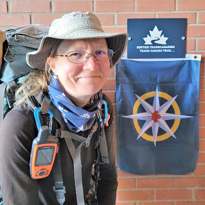
As we made our way along the row of four story, light grey stone buildings that face the waterway until we reached our goal: the headquarters of the Trans Canada Trail! According to our calculations, Montreal represented an important milestone for us - the point at which we'd walked 10,000 km on the beautiful trails of Canada!

For us, this milestone is a big deal - after all, it's taken us three seasons and more than 365 days of hiking to get here. However, as with many such moments in life, we were about to receive a healthy dose of humility. We'd been hoping to meet up with the new staff at the Trans Canada Trail in the hopes of beginning a strong relationship like the one we shared with the Great Trail team who had been amazing supporter of our Hike4Birds and our message of diversity in the outdoors throughout 2019 and 2020. Throughout the year we had not received a response from any of our project proposals or emails. Unfortunately, our requests for a meeting today - as we had hoped to get some of the trail staff out for a walk on the TCT itself - also went unanswered, so we contented ourselves with stopping outside the Trans Canada Trail headquarters to take a selfie with the new TCT sign and the Royal Canadian Geographical Society Expedition flag.

As we stood there a very nice lady from the TCT office walked up and asked us who we were and what we were doing. When we said we were Pathfinders on the Trans Canada Trail and we'd just finishing walking our first 10,000 km of it, she very kindly said 'Oh, that's nice! What’s a Pathfinder? What are your names? I don’t think anyone here knows that anyone is hiking the trail right now.' She very kindly invited us to take a tour of the TCT office, although she noted that she was the only one not working from home at the moment. As such, despite having published over 700 blog entries on our #hike4birds since 2019, taken and shared many of our 500,000 photos from the trail, shared over 1,000 Instagram updates and Facebook posts, been named an RCGS Expedition in 2021, appeared in the media over 100 times, been nominated for National Inspire Awards by the Canadian Museum of Nature, having worked with nature and conservation groups across the country, having published articles on the Trans Canada Trail with the award winning Eh Canada Travel website, and even having received a letter of encouragement from the Prime Minister, no one at the trail headquarters even knew we existed!
Well, that would certainly explain our difficulties trying to arrange a meeting, or share articles or images with the TCT in 2021.
After she went inside I was both devastated and very surprised to hear Sean laugh. When I looked up at him he simply quoted a line from one of his favourite songs, the Lumineer’s Flowers in Your Hair, commenting… “it's a long road to wisdom, but it's a short walk to being ignored” …
As surprising and painful as this moment was outside of
the Trans Canada Trail office, there is also no doubt that this instance was a firm
reminder that even amid the largest undertakings and at the height of personal accomplishment, none of us should take
ourselves or our achievements too seriously.
In the end we need to hike our own hike and live our own life, because we
believe in what we are doing - not because we want to be noticed.
Humility is a good thing, as is grounds your perspective. However, there is no way to pretend that this didn't really take the wind out of our sails. Our goal has been outreach, and we've spent a huge amount of time trying to create and maintain a positive forum where people are inspired to visit new places and to reconnect with nature in new ways. We have done everything we can think of over three years to show Canada to Canadians and encourage them to explore their country. Yet if the very organization we collaborated with a year ago hasn't even heard of us, how effective have we actually been?
I think the answer to this lies in the hundreds of people we've met on the trail, the stories we've shared with regional trail builders and naturalist clubs along the way, the classrooms we've talked with across the country, and in the kindness, generosity, and support that hundreds of people have shown us on our journey. For us, one of the most rewarding aspects of what we do is hearing from people who have decided to visit a new place, hike a new trail, try using iNaturalist or try Citizen Science for the first time so they can help conserve nature.
In a world where a tsunami of naysayers tries to destroy curiosity, creativity, innovation, and positive action, we end our hike this year resolved to continue trying to be a voice of inclusion, inspiration, and encouragement for anyone who is willing to listen. I know that inside what we are doing and what we believe in is a worthy cause and an important message – and so we will continue on to the Pacific and to the Arctic.
Very much humbled after so much work we walked quietly off and down the trail that we have followed for so long.
Just
45 minutes later we were checked into a local hotel, doing our laundry, printing off train tickets, and setting out to buy fresh clothes to get back to Ontario in. Just
like that we were no longer intrepid hikers, pilgrims or RCGS explorers …in just a few moments
we had transitioned into just regular tourists.
Have
now trekked here from the East Coast with only a small section behind us and
about 10 days of hiking in front of us to get to Ottawa to complete the TCT
from the Atlantic to Alberta. An exciting prospect! Given the weather and our condition however
we are leaving the remainder of Quebec for the Spring of 2022 before returning
to the Alberta border and pushing to the Pacific coast!
Thank you to everyone how has followed along for yet another great season of hiking! It has been, as always, a privilege to have you Come Walk With Us.
See you on the trail!
Remember to follow our entire adventure here : www.comewalkwithus.online
Comments
Post a Comment