The Way Provides : Magog to Eastman

Today began with one of those special autumn mornings that it is a true privilege to witness. As the sun came up around 6:30 am it turned the sky a pale yellow, and the mountains surrounding Lake Memphremagog were set aglow. Delicate white fingers of mist rose from the smooth dark waters of the lake and snaked across its surface in mesmerizing patterns. Two Common Loons made elegant silhouettes as they swam through the mirror-like waters, leaving a wake through the mist. Hills and mountains receded into the distance.


We walked around the beautifully treed Pointe Merry urban park, enjoying the view over the lake and back toward the town of Magog as we waited for the bakery to open. To the north the dark shape of Mont Orford dominated the horizon, and we could see the chairlifts for the ski hills way up at the top.


Around 8:00 am we discovered that the bakery was in fact closed just for today, so we “settled” for a hearty breakfast of coffee, omelettes, toast, and fresh fruit instead. Although it was a lovely way to begin the day, we ended up leaving quite a bit later than we intended, and the fantastic scenery did nothing to quicken our pace through town. Some things are just meant to be enjoyed !


We walked along the paved bicycling path that followed the shore of the lake. A landscaped park with benches and pavilions separated us from the water, and on our other side were colourful, modern, glass fronted condos. Many people were out strolling along the trail as we headed out, enjoying the view and exchanging friendly greetings as they went.


Work crews had begun to install Christmas decorations along the main street and the waterfront, and there were a lot of art installations along the trail as well. One of these was a large bronze statue of a man on his knees looking up and outwards across Lake Memphremagog. It was named 'Libre' or 'Freedom' and underneath was a poem by Christine Archambault. The words seemed to say 'I am all ages and all nationalities, I am yesterday and tomorrow, today and now, I am free.' It gave us food for thought as we looked out over the placid lake with the blue mountains rising up at the far end.


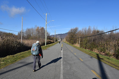

We continued along the paved and landscaped trail, which had one lane for walkers and two for cyclists, to the edge of town. Along the way we passed a large cattail marsh on the shores of the Rivière aux Cerises, and we could see a wooden observatory platform out in the middle. We soon realized it was likely accessed from the Centre d'Interpretation du Marais. The Nature Center was housed in a modern wooden and glass building that was tucked into the trees along the edge of the highway, and it seemed to offer several levels of educational spaces, as well as access to a network of trails and boardwalks.

Beside the centre was a very well-landscaped Halte Velo with a small garden, several picnic tables, and a shed decorated with artwork showing porcupines made using printed drawings of the animals that had been decorated with fall leaves. The nature artwork was very cute!


We couldn't help but divert into the Marais de la Rivière aux Cerises Nature Centre to explore its trails and boardwalks. It is located on the Cherry River Marsh on a 1.5 km sq property that includes woodlands, marshes, swamps, and peat bogs that support a truly impressive diversity of birds, mammals, amphibians, and reptiles. Over 166 bird species have been reported on eBird from the location, and we were very excited to see a red brick chimney erected to provide nesting habitat for Chimney Swifts!


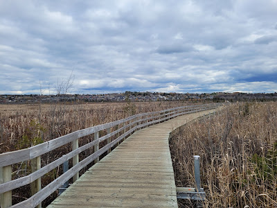
We made our way through the network of accessible trails, enjoying the interpretive signage along the way, which provided information on the flora, fauna, and ecology of the area. As we followed the wooden boardwalk through the marsh we had a gorgeous view of Mont Orford on one side and the town on the other. We also stopped to read about the history, geology, industry and restoration of Magog along the way.

Part of the history explained how the marsh had been impacted by dams on the Cherry River. The first dam was built in 1796 by Nicholas Austin, to power a mill. A few years later it was rebuilt to power additional flour mills, sawmills, and carding mills, and in the 1880's another dam was constructed downstream to provide hydroelectric power to the Magog Textile and Print Company. In 1920 a new power plant and an additional dam were built. All of these dams caused the water level in the lake to rise, and the area of the wetland to increase. Today the lake provides hydroelectric power and drinking water to several towns in the US and Canada, and it's water levels are tightly controlled.

The development of the train in the region also affected the marsh. In 1875 a line was built from Magog to Waterloo that went straight through the wetland, which was smaller at the time. Further development in the region and increased activity from recreation and tourism have also impacted the marsh, which is estimated to have shrunk by 30% since European settlers arrived. In recent years a lot of restoration work has gone into rehabilitating the area, and providing opportunities for people to connect with nature.


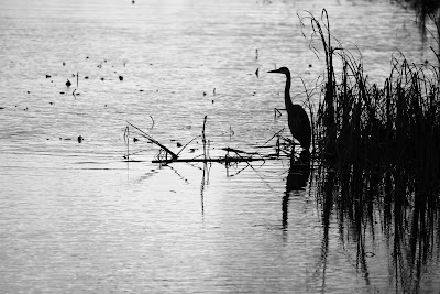
We followed the curving boardwalk back to town, happy to see that many people were out enjoying the nature trails and the beautiful weather. This late in the season we didn't spot too many birds, but a Great Blue Heron fishing in an area of open water was a definite highlight.


After making our detour we retraced the trail back out of town. A short stretch of paved trail took us alongside the road, past a small green field with a group of white cows with curly coats (this was a new sight for us), and a large barn selling fresh smelling wood.


We then crossed the rather busy road, and began an undulating section of trail paved with brand new black asphalt. On one side was a beautiful forest of sugar maple, American beech, Eastern hemlock, tamarack, and towering white pines that climbed the hill beside us. On the other a grassy strip with an ATV and snowmobile track and a strip of trees separated us from the highway. Coppery oak leaves crunched under our feet, the sun shone in a blue sky above us, and the rich colours of fall seemed to glow around us.


Eventually we emerged onto a very short section of road, and then turned northward onto another section of crushed stone dust trail. The winding and undulating pathway took us through stands of hemlocks and spruce, where the sunlight filtered down through the dark green needles high overhead, and the tall tree trunks made linear shadows across the trail.
For much of the way a small creek burbled next to the trail, it's clear cold waters singing as they flowed around mossy rocks, circumnavigated fallen logs and branches, and tumbled over tiny waterfalls. Sunlight dappled the rocky bottom of the creek bed, and bright red and yellow leaves sailed down the creek in the current.


In other areas we walked through open stands of sugar maples, American beech and white oak. Many of the leaves had fallen, creating a deep, soft, warm brown carpet of leaves on the forest floor through which delicate green ferns poked up into the sunlight. American Red Squirrels and chipmunks moved through the leaves, busily preparing for winter.
The path gently and steadily descended as we approached the community of Orford, even though we could see the hills and mountains rising up all around us. Soon we began to see homes tucked into the trees on either side of the trail, and not long afterwards the pathway emerged into a housing development, where it paralleled the road. Our first view of the resort community was of the Espace 4 Seasons - a truly huge, glass walled hotel with balconies looking out over the forested hills and mountains that surrounded us.


The winding street we walked along was lined with ski chalets, modern cube homes constructed of glass and metal, small restored log cabins, stone cottages, and cozy looking homes, all tucked into the trees. This region offers a range of outdoor activities - including cycling, hiking, kayaking, and ATVing in summer, and skiing (both cross-country and downhill), snowshoeing, skating, and snowmobiling in winter. In many ways, the homes in the region had a similar feel to those in Jasper, AB, or Blue Mountain, ON, and other resort towns across Canada.


As we made our way through Orford the trail forked, and we took a small detour down a branch that was lined with art and poetry. Here we discovered a Poetry Trail on which laminated poster boards with reproductions of paintings by local artists and poetry by local writers were tied to the trees along the pathway.


There were also ornaments created from natural materials, including feathers, pinecones, leaves, wooden beads, and gourdes hanging from tree branches. There must have been over 50 pieces included in the exhibit, and we really enjoyed experiencing the artwork in the natural, outdoor setting. At the end of the trail was a stand with wicker basket filled with natural materials and an invitation to create your own artwork and add it to the display. What a great idea!


When we reached the end of the forested poetry trail we emerged into a park with a large modern sculpture and a larger-than-life replica of an old transistor radio. The sculpture was created by Yves Trudeau, a world renown sculpture and professor who was born in Montreal and who founded the Association des sculpteures des Quebec. Although modern art is not something we can even pretend to understand, we are really enjoying the way art, culture, and cuisine are mixed with nature along the trail in Quebec.
By following the poetry trail branch we bypassed the 'downtown' portion of Orford, so we backtracked down the trail on the main street. It was lined with restaurants, B&Bs, antique dealers, small boutique shops, a microbrasserie, several cafés (mostly closed), a variety of chalets and hotels, and several historical buildings. We stopped for a hot chocolate to warm our hands, and enjoyed it at a picnic table under the pines in a nearby park.


As we made our way north out of town we passed a large resort and golf course, and then diverted off the main road into a housing development of unique looking homes. The dark brown wooden cottages had huge, sloping, bright orange metal roofs on one side, giving them a sort of wedge-shaped appearance. It turns out the cottages were part of the Cheribourg development, which was founded in 1968. It now contains 290 cottages, the Cheribourg hotel, a health spa, two swimming pools, a fitness center, and badminton, tennis, and volleyball courts. The orange roofs were supposed to emulate the tiled terra-cotta roofs of Europe. To us the development looked very much like it belonged in the 1970's, and there was a lady out doing yard work who was dressed in clothes straight out of the '70's as well, complete with rose tinted glasses.

After making our way through the homes the road began to climb and became narrower and narrower until it was little more than a track. Just as we were wondering whether we had gone wrong, and were walking up someone's driveway, we came to the boundary of the Parc du Mont Orford, which was delineated with a small gate, a pavilion with a map, and a request to pay the entrance fee online.


The Mont-Orford National Park (a provincial park, not run by Parks Canada) is 58 sq km and encompasses several mountain peaks, including Mont Orford, Mont Giroux, Mont Alfred Desrochers, Mont Chauve, and the Massif des Chênes. The park is open year-round for camping, hiking, swimming, cycling, canoeing, kayaking, pedalos (water bicycling), row boating, rock climbing, paddle boarding, and wildlife viewing in summer and for alpine and cross-country skiing, snowshoeing, and Ski-Vel (wheelchair skiing) in winter. The ski area in Mont Orford has 61 alpine ski runs, with 1 gondola and 4 chairlifts.

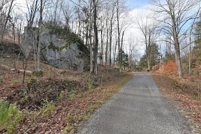
After digitally paying the entrance fee we began our walk through Mont Orford on the Sentier Transcanadien, which follows the Route Verte. We'd had some misgivings about this section of trail, because we weren't able to determine how difficult or hilly it was going to be. The Route Verte trail descriptions warned of an 11% grade, and the videos we'd been able to find of people hiking the trails showed them climbing and scrambling up incredibly steep, rocky slopes to lookouts near the top of the ski runs. There is a network of trails through the park which range from easy to difficult, and as logic would suggest, the Route Verte turned out to be a wide, level, cycling trail which was easy and very enjoyable to navigate – with no rock scrambling for us involved.


Our walk through the Parc du Mont Orford was incredibly beautiful. We could see the mountains all around us, and forested hills rose steeply up on either side of the trail. The slopes were mostly covered in sugar maple and American beech stands, mixed with white birch and eastern hemlock. Large moss covered erratics dotted the landscape, and periodically small, clear streams flowed down the steep mountainsides.


We passed quite a few people out walking in the sunny afternoon, many of whom gave us a friendly greeting as they passed. Although we only saw one cyclist, we could imagine that during the summer months these trails might be very busy. Just as we passed the cyclist she began a steep descent, audibly picking up speed as she went and then making a sharp turn at the bottom of the hill at high speed. We realized once again how lucky we are to be hiking in the off season, when we aren't presenting an obstacle to cyclists.

As we approached the centre of the park we came to a small lake. A trio of Hooded Mergansers were swimming out in the middle of the water, repeatedly diving for food as they circled a large snag. A small beaver dam blocked the water flow out of the pond, and two lodges broke the surface of the pond, which reflected the sun bathed forest surrounding it. It was a very peaceful and beautiful spot.


By early afternoon we had reached the Visitor's Centre near the middle of the park. We took a break at the picnic tables outside the large glass centre and watched with some trepidation as the staff brought out the racks of cross-country skiis and other winter sports equipment that will shortly be available to rent. As we sat there, grateful for the sunshine but aware of the falling temperatures, we enjoyed a magnificent view over a small lake. The rock islands in the middle, topped with tall white pines, and the forested slopes surrounding the deep blue waters could have belonged anywhere in the Boreal, or on the Canadian Shield.


After a short break we continued down the final 6 km of trail to the western edge of the park. As we looked up at the dark, steep, slopes of Mont Orford we were surprised to see a dusting of snow on the ski runs. We hadn't remembered seeing it this morning. As the afternoon progressed we also noticed that many of the puddles at the side of the trail had frozen over.


The ice created interesting geometrical patterns on the hard surface, the colourful leaves visible below. We spotted icicles among the emerald green moss and ferns on some of the larger glacial erratics. If we needed any impetus to hurry up, the nip in the air and these hints of winter were definitely it!


As we approached the western edge of the park we began to see more interpretive signs along the trail, explaining the ecology of the region's forests. We learned how the area used to be covered in a glacial ice sheet that was 2 km thick, which was difficult to accurately imagine. We also learned that it is the rich soil and differences in temperature and moisture that allow the sugar maples to grow on the slopes on the hills, while eastern hemlocks grow on the steep sides and damp, cool, darker valley bottoms. One really cool fact I didn't previously know was that eastern hemlocks can be used as compasses. Apparently the tip at the very top of the hemlock tree always points east!


At the far edge of the park we came to another parking lot. The walk back down to Eastman was a lot like the walk into the park had been - a mix of forested trails and short sections of roads through small housing developments. We picked up our pace a little as the temperature and light levels began to drop and the late afternoon wore on. Just as darkness was falling we made it to the northern edge of the small community of Eastman, bringing what felt like a very long and full day to a timely end.
See you on the trail!
Remember to follow our entire adventure here : www.comewalkwithus.online
Comments
Post a Comment