Birding the Canal : Saint-Gregoire to Chambly
The ‘Come Walk With Us’ expedition and #Hike4Birds is somewhat of a Catch-22 for me. I often feel as though I am caught between two drives. One part of me definitely wants to inspire others, wants to get others out there and wants to share the adventure while admittedly the other part of me just wants to get out onto the trail, into nature, into the wild and to do my own thing. I admit that there are times I have held experiences and situations back from the blog because they are too personal or refrained from responding to emails and critiques because I just don’t want to go to the dark places where those types of messages go. Sometimes knowing and deciding what to share, how to share it and what not to share while being honest about our experiences has been a real challenge.
After all things happen when you leave your house, are out on the trail, or are hiking across an entire country. You see wildlife, you see natural wonders, you have unfortunate encounters, and you have experiences you wouldn't have if you had stayed home. In figuring out how to describe some of these events it isn't a 'judgment' on a region, an 'attempt to condemn a town' or striving to 'paint an entire province of people' - as some have suggested, it is simply relaying what happened on a particular day in a particular moment.

The difficulty in portraying moments is made all the more
taxing by the fact that travel stories and blogs don’t seem to be the place
where most people want to read about challenges on the trail, unfortunate
encounters, learn about the country, or consider historical and regional tensions. Instead with blogs, people seem to only want to be told - in the words of Garrison Keillor - that their town is the greatest in the world, "where all the women are strong, all the men are good-looking, and all the children are above average". It is of course understandable and human nature to not want to hear about troubles and deal with the unpleasant realities in our communities. We all idealize our home towns and are are all quick to defend them when critiqued. Yet so much of each person's life turns on interactions, discourses, and moments which naturally challenge our expectations and norms. Challenge is how we grow as individuals and as a society. If we aren't willing to listen or have new experiences we can't grow.
The fact also is that often I don’t know how to talk about or present many of things we come into contact with while trekking across this beautiful nation. How am I to talk about meeting anti-vaxxers or Covid doubters? How to portray those land owners who dislike the Trans Canada Trail and are very vocal about it to someone simply walking? How to discuss Indigenous histories and Reconciliation? How to present the views of Prairie residents on Carbon taxation, their frustration with centralized decisions and their lack of representation in Ottawa? How to talk about the Quebec Nation or the French language debate? How to talk about Bird Conservation and Climate Change amid regions whose livelihood depend upon mineral extraction and oil production? Each of these are serious and important issues in this nation and certainly need to be respectfully figured out. Each of these are also topics which we come into contact with on the trail. And each of these topics are ones which I simply lack the words and the wisdom to convey or provide solutions for.
"When we try to pick out anything by itself, we find it hitched to everything else…”
John Muir
The truth is that trekking along the Trans
Canada Trail from the Atlantic to the Pacific to the Arctic has and will
continue to put us at the crossroads of many of our national debates and I
suspect that I, like so many others, struggle with what to think about them. Our role as explorers and
storytellers is to relay the experiences that we have, to reveal the world from another perspective, and show
the possibilities for the future. Yet after almost 10,000 km of trekking and more than 365 days on the trail, about
all I know is that despite all the challenges, differences, and apparent tensions we see...is that Canada is
worth it, that we are stronger together, and that there is a lot in this country to be both proud of as well as feel optimistic about. As Canadians we don't acknowledge that as much as we should. Canada, despite its challenges, is wonderful from coast to coast to coast. This trek - like life - is very much a journey of discovery – and so, even if I don’t
have all the answers, I am still continuing on .... searching for insight and birds.

As such I have to admit that the main reason for delaying the publication of these blogs as we venture across Quebec as been my struggle with what to present and what to keep for myself. So as you read this entry a month or more after we have been here now you know at least part of the reason. Thank you for your patience.
Regardless of this divide there is no denying that my favourite part of this hike is to be active and in nature regularly – in this Quebec has been an amazing experience and Quebecers have been a welcoming people as we have crossed the province!

We rejoined the trail this morning at a
beautifully decorated Halte Velo located at the crossroads in Saint-Grégoire,
which had a picnic table in a wooden shelter painted with cheerful vines and
colourful animals. From there we followed the paved cycling path through
a corridor of trees under a very dark, heavy, overcast sky. Most of the
branches above us were bare, but the strong golds, rich coppery browns, and
pale yellow accents provided by the last of the trembling aspen, American beech,
and sugar maple leaves in the canopy seemed to glow in the dim light around us.

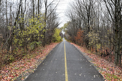


The first few kilometres were very peaceful. We watched grey squirrels busily collecting acorns and other treats in the leaf litter, and listened to the soft, high pitched chattering of Dark-eyed Juncos, White-throated Sparrows, and Black-capped Chickadees moving through the understory. With the exception of one older gentleman out walking his dog, we were mostly alone with our thoughts and the crunching of faded leaves beneath our feet.


Unfortunately a few short kilometres after leaving Saint Gregoire we began to hear the roar of the highway, and the sounds of Saint-Jean-Sur-Richelieu – a suburb in the Greater Montreal Area. The forest gave way to harvested corn fields, and before we knew it we were walking beside highway 133. The noise of the traffic was very loud, and our route was uninspiring as we essentially walked 2 km north through an industrial area to cross under the highway, and then walked back 2 km south through a neighbourhood of smaller, older homes to get back to where we were – ok 6 lanes of busy highway traffic away from where we were.


While this wasn't the most pleasing experience, we took a moment to remember all the times the TCT has had us cross the Trans Canada Highway simply by dashing across it and hoping for the best, or the many kilometres we've spent walking along its shoulders without the benefit of a dedicated trail, and we were very grateful for the paved cycling lane and the underpass.
After crossing the highway we found ourselves in the suburban neighbourhoods of Iberville. Iberville was founded in 1848 under the name of Christieville, in honour of Gabriel Christie (1722-99). Although his father donated the land on which the town is located, Christie was a soldier in General Wolfe's British army, which took Québec in 1759. The name was changed to honour the military career of Le Moyen d'Iberville instead. I guess it is easy to understand why Christie, an Englishman, would no longer be appreciated in this area.


The town is located in the fruit growing region of Québec, and it is known for its local vineyards. Our experience of it was simply to follow the paved cycling trail through modern subdivisions to the Richelieu River. We passed through urban parks, walked by schools, communal gardens with raised wooden plots, and tall stone churches. The trail was lined with saplings and young trees that had been planted as part of a larger provincial project aimed at planting 50,000 trees, and various sculptures and art installations were also located along its length.

Eventually the trail brought us to the shores of the very wide Richelieu River. This river begins in Lake Champlain, which is mostly located in the U.S., straddling the border between New York State and Vermont. It flows northward from Lake Champlain to the Saint Lawrence River, and is a major trade route that was used first by Indigenous Peoples and later for trade between America and Canada. Originally it was called the Iroquois River, then the Chambly River, and now it is named in honour of Cardinal Richelieu, a powerful minister under Louis XIII.
When we reached the shores of the river we took a moment to pause and admire the view of Saint-Jean-Sur-Richelieu on the far shore. We could see the homes and apartment buildings reflected in the steely grey waters of the river, a church steeple rose up behind them, and to our right the long white arch of Pont Gouin spanned the river. Even on the dark, overcast morning it was a beautiful sight.

The trail then took us up and over the Richelieu River on the new Gouin bridge, which thankfully had its own cycling lane. The original Gouin Bridge was built in 1915 just south of the current one built in 2019, which is 650 m long and allows 20,000 automobiles to cross between Iberville and Saint-Jean-Sur-Richelieu every day. It also provides an essential link on the Route Verte between the Montégériade and the Estriade regions.


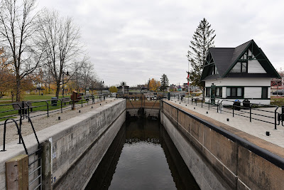
The bridge spans not only the Richelieu River, but also the Chambly Canal, which runs parallel to it. When we followed the curving bike trail back down to the water on the far side of the bridge we found ourselves in the Chambly Canal National Historic Site of Canada. The Chambly Canal is one of a series of canals that links Montréal to New York City via the Richelieu River, Lake Champlain, and the Hudson River. Together with the Saint-Ours Canal it commemorates the important role of the Richelieu in trade during the 19th and 20th centuries.
Construction of the 20 km long Chambly Canal began in 1831 and was completed in 1843. It served as part of a major trade route between the US and Canada until WWI, after which traffic declined when freight trains became a faster and both the more economical and efficient option for transporting goods. Since the 1970's traffic in the canal has mostly consisted of recreational vessels. The canal has ten bridges, eight of which are still hand operated, and nine hydraulic life locks.
For the next 5 km or so we walked on a built up dike with the wide, fast flowing waters of the Richelieu River on one side, and the shallow still waters of the narrow canal on the other. We could see colourful shops, cafés, restaurants, and clubs in the trendy looking downtown waterfront of Saint-Jean-Sur-Richelieu across the canal, but if we'd had any thoughts of getting a morning snack, we soon realized that would be impossible, since there were no bridges across the canal. Groups of fashionably dressed people were out walking designer dogs along the trail, giving the area a high end vibe.
The town of Saint-Jean-Sur-Richelieu is located at the northern most point of Lake Champlain, and has about 99,000 residents. Historically it was an important transportation hub, being located on the Champlain and St. Lawrence Railway (C&SL), which was the first public railway in Canada and one of the first railways built in British North America. This line connected Saint-Jean-sur-Richelieu with La Prairie in 1836. Today, Saint-Jean-sur-Richelieu is known for its annual International Balloon Festival, a hot air balloon festival that is held every day during the month of August, and attracts thousands of tourists each year.

As we walked along the dike, eventually the downtown gave way to homes and small apartment complexes across the canal, and the houses on the far side of the river became less dense. We could see huge rafts of Common Goldeneyes floating out in the river, and the canal beside us was utterly packed with thousands of Mallards and Hooded Mergansers. Double-crested Cormorants and Ring-billed Gulls perched on rocks out in midstream.

Parks Canada Interpretive signs lined the edge of trail, and one of the first points of interest we came to was Lock No. 9. The small white building at the lock had been restored, and signs explained that when the canal originally opened in 1843, the gates of the lock had been operated by hand, using a series of balance beams. In 1892 a system of winches and chains were added to make operation of the lock easier, and in 1970 hydraulic mechanisms were added. Throughout the day, similar signage explained the history of each lock we passed.
As we continued on, one of the highlights was coming to the Halte des Moulins Langeliers. In 1860 Charles Langeliers built a complex of mills at the foot of the rapids at this point on the river. He had a flour mill, a carding mill, and a tannery. The mills were at their height of operation between 1860 and 1880, but they eventually became obsolete when the steam powered mills of competitors outperformed them.
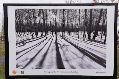


Today there is a small green park at the site, which has been dedicated in honour of Jacques Paul, a wildlife and bird photographer. We took a short detour through the green space to take in an outdoor photography exhibit that had been installed along the trail. Landscape, portrait, and nature photographs were displayed on stands along the winding pathway, free for anyone to enjoy. We have really been enjoying the art-in-nature exhibits installed along the trail here in Quebec!
The Halte des Moulins Langeliers is also known as a birder's paradise, with over 200 species being spotted in the area, including thousands of Snow Geese during spring and fall migration. Today we watched massive flocks of Common Goldeneyes foraging out in the river, as well as Canada Geese, Mallards, a Northern Pintail, Double-crested Cormorants, Ring-billed Gulls, Herring Gulls, a Bonaparte's Gull, and a Great Blue Heron.


As we continued on we were passed by quite a few other day hikers. One lady stopped to ask what we were doing and to chat, and ended by saying we're lucky to have such warm and nice weather for our hike, but that "it is good, but it was also not good, because it is not normal." Our sentiments exactly! When we think back to two years ago, when we were racing towards Rivière-du-Loup to finish our first season on the trail, it was snowing and -24°C on this day. Although we're very much enjoying the warm weather, having a 18°C day in November is yet another disconcerting and scary sign of climate change.


Eventually we came to Île Fryer, which is located between the Richelieu River and the canal, which widens out considerably at this point. We walked along the canal side of the island, which had been drained of nearly all its water. The wide, two-lane bicycle path was adjacent to a narrow one-way street for cars, giving the strong impression that non-motorized vehicles had priority.
The pathway was filled with walkers and cyclists out enjoying the sunshine. A mix of small and large homes, many with very interesting architecture, large windows, and well-landscaped yards dominated by large white pines lined the road. On our other side their private wooden decks and boat docks jutted out into the canal, many well above the reduced water level.


One of the most amazing things about walking the island pathway was that the canal beside us was ridiculously filled with several thousand Canada Geese, and more were joining them by the minute as large v's descended from the sky. This was evidently an important stopover point for migrating waterfowl, but instead of resting, the geese seemed to be socializing at high volume. The noise, which sounded like a huge cocktail party, was incredible and attracted the attention of everyone out walking or cycling.

Eventually the homes on both sides of the canal began to thin out, and we found ourselves walking beside a cattail and phragmites marsh on the canal side while corn fields lined the opposite bank. Apparently the wilder portions of island are a protected area for swamp white oak, a tree species that is dying out in many parts of Canada. At this point we came to the Fort Sainte-Thérèse National Historic Site ofCanada. Here not much of the original buildings were left and in their place was a large wooden archway and a historic plaque being the most visible reminders of the historic importance of the location.

During the 17th century there were actually three forts built in succession by France along the Richelieu River at this location. The first fort was built in 1665 by Henri de Chastelard de Salières, an officer of the Carignan-Salières Regiment. He finished the fortifications on October 15th, which was the day of Sainte Thérèse, after whom he named the fort.
In 1667 the fort was abandoned, but a second one was built in 1747 in response to concerns about the behaviour of the Iroquois in the area and threats from the English colonies to the south. It was used to house the boats of the King of France, a regiment of soldiers, and to store supplies during the British Invasion (1756-1759). In 1760 it was burned to the ground by Robert Rogers and his men, who were American Rangers.
During the British campaign on Montréal in 1760 the French and Canadiens sent troops to the site of Fort Thérèse, but it was later abandoned and the British took possession of the remains of the fort and built trenches around it. The strategic importance of this location came from its position at the head of a stretch of rapids along the Richelieu River, which was a major thoroughfare for goods and soldiers.

We took a break at the wooden benches at the base of the wooden archway, tucked into a treed, marshy area. The afternoon sunshine was so hot that Sean removed his pants legs, hiking in shorts and short sleeves for the rest of the afternoon. As we sat there a small swarm of midges circled around us, and we found our backpacks covered in lady bugs. I'm not an entomologist, but I can't imagine that any tiny flying insects should be hatching off the river at this time of year.


Shortly after leaving the historic site we walked past the Fryer dam. Its long concrete pillars and solid metal top spanned the wide Richelieu River without seemingly interrupting its flow at all, making it look more like a bridge. Plans for the dam were drawn up in 1937 in an effort to control water levels in Lake Champlain and the Richelieu River to protect communities along their banks. Although the dam was completed in 1938 it required the construction of dikes and a trench through the Saint-Jean-sur-Richelieu rapids. These additional projects were never undertaken, and the dam never became functional.


We continued our walk along the sunny dike for another few kilometres, enjoying the warm afternoon sunshine. Every so often we stopped to read the historical plaques provided by Parks Canada alongside the locks and bridges of the Chambly Canal. As we approached the town of Chambly we ran into yet another 'Route Barée' sign, this time because work crews were replacing a section of the cycling trail. We detoured around the construction by threading our way through the lock system, and were somewhat amused by a pair of very elderly ladies who stopped to ask if the route ahead was actually closed, or if they could get by. We said they could manage, and off they went, happy to enjoy the afternoon sunshine and undeterred by the orange pylons and obstacles in their path.


We made our way into town and were delighted to find an available room in a motel whose mirrors, faux rock walls, and general decor could have come straight out of the 1960's. The lady at the reception desk was extremely nice, and suggested we explore the historic neighbourhood across the bridge and visit nearby Fort Chambly. Accordingly, we deposited our packs in the room and went to discover the town.

Samuel Champlain passed through the area in 1609, and it was easy to see the town is rich in history. We began by visiting the renowned Fort Chambly National Historic Site of Canada. The large stone fort, which stands right on the edge of the Richelieu River, is actually the fourth fort to have been built on the site. The first incarnation was built in 1665 under the direction of Jacques de Chambly, captain of a detachment of the Carignan-Salières Regiment, in response to Iroquois attacks on the French settlers. It was the first of five forts constructed at strategic points along the banks of the Richelieu River around that time. The original structure was continually expanded over the years, especially from 1702 onward as a result of the War of Secession with Spain, which opposed Britain and France.

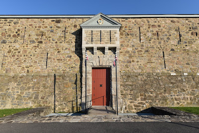


Between 1709 and 1711 the original fort was replaced with a stone structure built according to the principles of Vauban. It was named Fort Pont-chartrain, but it wasn't immediately used since the Treaty of Utrecht brought current hostilities between Britain and France to an end. In 1775 the Americans invaded Canada and occupied Fort Chambly, until they were defeated by the British at Quebec City.

As they retreated south to Fort Ticonderoga they burned the fort behind them. Later the British occupied Fort Chambly, repairing and expanding it to accommodate infantry barracks, up to 6,000 soldiers, and regiments of artillery, cavalry, and engineering. The Fort was abandoned in 1860 and left to deteriorate in the elements until Joseph-Octave Dion set up a residence there in 1880 and began working to save the old fort.
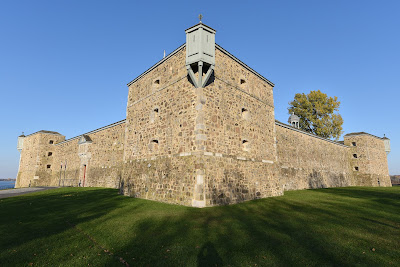

Although the fort, a Park’s Canada site, was closed when we visited, the grounds were full of people out enjoying the warm afternoon sunshine and the beautiful views out over the rapids of the Richelieu River. Picnic tables were scattered throughout the green space, under tall mature maples. We stopped at the concrete barrier along the water to watch the flocks of Canada Geese, Mallards, Ring-billed and Bonaparte's Gulls, and Hooded Mergansers foraging out in the fast moving waters. We also spotted a couple Double-crested Cormorants, Scaups, and American Black Ducks. Not only is the spot rich in history, it is also a great place to watch birds, with 189 species being reported there on eBird over the past couple of years.


We followed the riverside path around Fort Chambly and then into a neighbourhood with many large, stately stone homes on well-landscaped and gated riverside properties. Many of these elegant homes had historic plaques outside explaining when they were constructed and who occupied them. Lots of people were walking along the brick sidewalks, stopping to learn about the history of the town, reminding us a lot of Niagara-on-the-Lake in Ontario.


We continued through this elegant neighbourhood until we came to the Parc des Rapides. This large treed green space featured a large war memorial, additional historical plaques, many picnic tables under a canopy of shade trees, and great views of the rapides in the Richelieu River. We walked down to the water's edge, and stood looking up at a very tall weir. The water flowed over the forbidding black wall in a smooth sheet before exploding into spray at the bottom, only a few feet from where we were standing.

After pausing to watch the mesmerizing way the water danced and sloshed across
the rocks, we made our way back along the main street, through a surprisingly
plain stretch of homes and closed shops, and then into an upscale downtown
street that was lined with cafés, bars, and restaurants, half of which backed
onto the river.


We found a small and inexpensive restaurant in which to get a bite to eat, and then made our way back to our room for a Zoom call, a late night presentation on the west coats, and then to get down to work. As one of the final days we'll spend on the trail this year, it was a very enjoyable and interesting one indeed.

See you on the trail!
Remember to follow our entire adventure here : www.comewalkwithus.online
Comments
Post a Comment