Velo Trails and Brothels : Eastman to Granby
This morning began as many mornings here in Quebec have recently - with an overcast sky that gave way to gorgeous soft pinks and yellows as the sun peaked above the horizon. We set out early to get a head start on a long day. Around us the hills and mountains were stained blood red by the rising sun, and a thick white frost covered everything, turning the grasses, cattails, and branches white. The trail sparkled and our footsteps crunched as we made our way through the magical world.


For the first few kilometres we walked through a quiet, peaceful landscape. It appeared almost black and white with its coating of frost, punctuated only by the golden needles of the tamaracks. The smell of wood smoke filled the air, and we could hear the sound of a train whistle in the distance. Tall forested hills rose up around us, and beyond them the steep slopes of mountains darkened the sky.
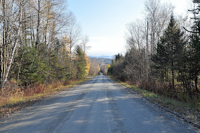
We crossed the highway when we reached the tiny village of Stukley-Sud and continued along the Chemin de la Diligence. The undulating road passed picturesque farms with iconic wooden barns, apple orchards, and horses standing patiently in their fields and paddocks, their breath making shifting golden clouds in the crisp clear air.

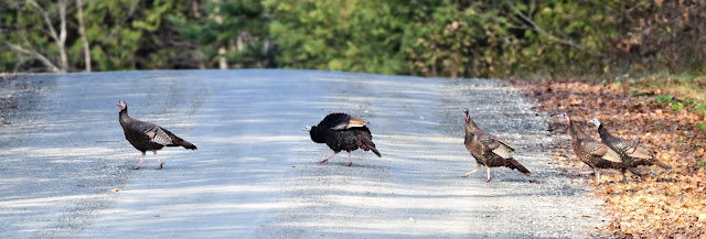
As we climbed a hill bordered by a small cattail marsh and lined with mature trees, a flock of about nine Wild Turkeys walked slowly across the gravel road ahead of us before disappearing into the woods. A short distance later we scared a group of Mourning Doves up out of the leaf litter where they'd been sunbathing at the edge of the road. We were happy to see that quite a few properties we passed were listed as nature preserves and wildlife habitat.


One of the things we've been enjoying as we cross Quebec is seeing an assortment of road signs that we don't recognize from other parts of the country, and sometimes can't figure out how to interpret. Today we saw several entertaining signs, including a unique representation warning not to collide with farm equipment when cresting a hill on the road.
By late morning we left the gravel road and diverted onto a crushed stone dust cycling trail that continued through beautiful pastoral countryside. Almost immediately we spotted a pair of White-tailed Deer grazing at the side of the trail ahead of us. A pair of brightly coloured Blue Jays flew by overhead, and a large flock of European Starlings chatted softly to each other in the treetops beside us.


As we walked we noticed pieces of Canadian Shield lining the trail, intrepid yellow birches and eastern white cedars reaching their roots around the exposed rocks to anchor in the rich soil below. Large moss covered glacial erratics also periodically appeared among the sugar maples, American beeches, and eastern white hemlocks, as we crossed several tiny creeks and streams that trickled and sang quietly among the trees.


By late morning we reached the outskirts of Waterloo. This town was settled in 1793 by Ezekiel Lewis, an English Loyalist supporter from New Hampshire, who named it Lewis Falls. Ezekiel eventually sold his original plot of land, and after it changed hands a few times, Hezekiah Robinson bought it and re-named the town Waterloo after the famous battle in which Napoleon Bonaparte was defeated. In 1861 Asa Foster brought the railway to Waterloo, which helped it expand into a thriving town. Many of the stone and brick buildings in Waterloo date from the late 1800's, and the road that Foster put in still serves as the main street for the town. Famous people who came from Waterloo include A.B. Foster, who was known as "Canada's Railway King" and J.R. Booth who became one of the wealthiest men in this new country and was known as the "Lumber King of Canada."
We passed through most of the town on a paved cycling trail lined with trees, but caught glimpses of old stately homes, a beautiful treed central park with hearts hanging from its tall white pines, a beautiful old church that had been converted into a theatre, and a main street lined with brick and stone buildings.

We took a break at the old restored train station which served as an information centre and café for trail users. Sadly the café was closed, but we enjoyed our chocolate almandines from the bakery in Magog at a picnic table in the sunshine while a large group of cyclists enjoyed their snacks at a nearby bench.
As we made our way from the train station to Lac Waterloo we walked down a paved promenade lined with sculpted gardens and art exhibits, each with an interpretive sign. Among the large metal animals were a lion, an eagle, and an owl, and to our amusement there was a domestic cat sitting below the larger-than-life lion, trying for all it was worth to look like it belonged.


We crossed a wooden pedestrian bridge over the water and followed a paved bicycling trail around the shore of the lake, enjoying the view on what had become a warm, sunny, afternoon. As we followed the treed and naturalized shore we could see the buildings of downtown across the water.
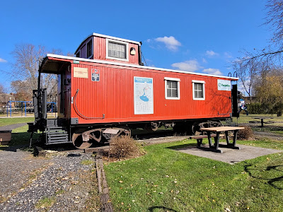
On the edge of town we came to a small rest stop and park with a restored railway carriage and a plaque commemorating Asa Belknap Foster, the powerful businessman and politician who helped found Waterloo. He represented Bedford division in the Senate of Canada from 1867 to 1874 as a Conservative member, and is believed to have provided information to the Liberals that led to the Pacific Scandal.


As we left Waterloo we noticed a marked change in the Route Verte. Until today we've generally seen a lot of people walking the trail, especially in the towns and built-up areas. Although we've seen plenty of cyclists, they've mostly been single riders or elderly tourists going at a leisurely pace, and we haven't generally been encountering more than 2 or 3 an hour. On this sunny Saturday afternoon the Route Verte transformed into a the very busy velo route we had long ago been warned of.


As the afternoon wore on we were passed by a relatively constant stream of fast
moving cyclists going in both directions. Groups of two or three riders would
approach each other, all riding side by side, and they'd only swerve at the
last second to avoid collisions. We frequently stepped off the trail to
let groups of people pass, and spent much of the day hearing cyclists race up
behind us impatiently ringing their bells – ‘ding ding’ – or yelling “bouge bouge
bouge’ / ‘ move move move’ at us as they passed. Added to the change in the pace of the
pathway were an increasing number of electric mobility chairs and e-scooters
racing silently down the trail. Not once did a single cyclist make any attempt to shift their roue on the pathway to make room for us trekking along the trail's edge.
Rarely has the pace of the TransCanada Trail so rapidly changed and never have we seen so many people in brightly coloured spandex in one place at one time.


Although we were a little daunted by the crowds of people on the trail today, we assumed this was only a very small taste of what the cycling pathways would be like in high season. Once again we were grateful to be walking during the shoulder season, and to be approaching Montreal during the week and not on the weekend.

A few kilometres west of Waterloo we came to a Sentier Transcanadien pavilion at a crossroads. It had the old style red roof, and while a few panels recognizing important donors to the trail remained, the trail map and most of the other panels had been removed. Now that the trail has been re-christened the Trans Canada Trail again, we wonder what the new pavilions will look like.


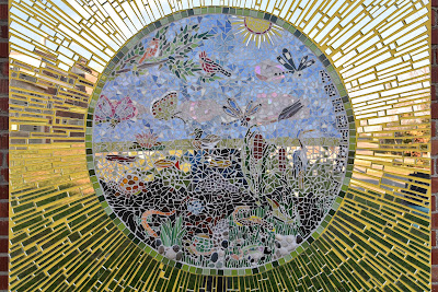
As we headed west towards Granby we noticed that all of the Halte Velos had
art installations at them. One of them had a tall, hollow, concrete
cylinder with a slit in the side that was standing upright. Inside the
cylinder was a model of a giant ear, and the outside of the cylinder had faces
emerging from it on all sides.


At another Halte Velo there was a giant concrete figure lounging on the ground, taking a break.

Seeing the different art exhibits along the way was something to look forward to as the afternoon wore on.

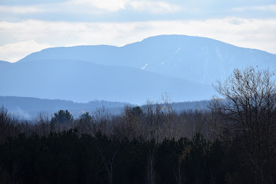
As we made our way through the countryside we began to see mountains rising up around us once again. In particular, we could see the dark shape of Mont Bromont standing imposingly to the south, the ski lifts clearly visible from the trail. Just like in Mont Orford, the ski runs at the top of the hills were dusted with a layer of snow. Once again the warning to us was clear – the weather is changing.


By early afternoon our energy was beginning to flag, and we took a break at another Halte Velo which had a beautiful view out over emerald green fields with layers of mountains disappearing into the distance. On the other side a large wooden barn and its surrounding outbuildings were nestled into the forested hill above it. Sitting there it struck us how beautiful that particular place and moment were.


Today was a 42 km long hike, but for some unknown reason during the last 15 km
of it we seemed to make no progress at all. It was a flat, paved cycling
trail all the way from Waterloo to Granby, with picturesque scenery, rest
stops, and really no challenges apart from the stream of racing cyclists
peddling 2, 3 and 4 bikes across the pathway who rarely gave way to anyone else. However, it felt like
Granby was a geographic anomaly that remained 15 km away no matter how long or
far we trekked.


Around 3:30 pm we finally came to the stretch of trail that ran through a linear park along the Yamasaka River on the edge of the town of Granby. Lots of people were out cycling and walking the beautiful forested trail that followed the shore of the wide river at the edge of town. We could see the buildings and church steeples of Granby across the waters, and out in the middle of the river were several huge rafts of Ring-necked Ducks. They were clustered in tight groups, splashing and thrashing around, presumably feeding on groups of fish in the waters below them. We also spotted quite a few small groups of American Coots swimming and diving out on the river.


The Yamasaka River is 177 km long, beginning in Brome Lake and flowing into the Saint Lawrence River near Lac Saint Pierre. It crosses 20 municipalities, providing a source of fresh drinking water to the communities it passes through. It was originally called 'Rivière de Gennes' by Samuel Champlain in 1609, but it's current name first appeared in the 17th century. The word Yamasaka is derived either from an Abenaki word meaning 'there are rushes off the coast' or 'there is hay nearby', or from an Algonquin word meaning 'river of the savannas' or 'river with muddy waters.' Either way, both names likely refer to the abundant marsh vegetation and aquatic grasses that grow at the mouth of the river.


Before European settlement the Yamasaka was rich with life, but urban, industrial, and agricultural uses have since made it one of the most heavily polluted rivers in Quebec. Many communities along its length have made concerted efforts to mitigate the negative environmental impacts affecting it. Citizens, environmental experts, municipal councillors, and groups dedicated to studying, inventorying, and conserving the river have come together in Granby, which has led to an increase in art, events, and festivals aimed at giving a voice to the plants and animals who cannot speak for themselves, and at educating people on how they can alter their individual actions to help preserve the river.

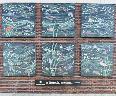


We saw evidence of these efforts at the Halte des Piétonnière des Génerationsat the edge of town. A small water treatment building was covered in a colourful mural of what looked like a river spirit speaking the words 'Urgence Yamasaka.' In front of the building was a spiral brick walkway decorated with tiled pictures of birds, insects, amphibians, fish, and plants that rely on the river for life. In the grassy park surrounding the area there were other art exhibits and many interpretive signs providing information about the river and its conservation, and a short distance along the trail we came to another red brick chimney that was installed to provide habitat for Chimney Swifts.


We continued down the landscaped walkway, past upscale condos, a spa, and a hotel. As we threaded our way through the people out enjoying the afternoon a lady stopped and asked if we were pélèrin on the compostelle, saying she noticed the shells on our packs. It wasn't the first time someone has asked us if we're pilgrims before wishing us well on our journey. The answer is complicated - in some ways we will always be pilgrims having trekked to Santiago and to the end of the world a number of times. However the simple fact is that the end goal of this particular walk isn't Saint Anne-de-Beaupré, or any other cathedral in Quebec and so we too wonder are we still pilgrims?

When we got to the edge of downtown we passed a very large concrete hippopotamus that was painted bright green. This was the first of several very large and colourful animals we saw around town, which pay tribute to the Granby Zoo. This zoo was founded 1953 and houses over 1,800 animals representing more than 200 species from all over the world. With over half a million visitors every year it is considered one of Quebec's major tourist attractions.


We soon stepped off the riverside walkway and the TCT making our way up the main street of Granby. The town has around 67,000 inhabitants, and is the county seat for La Haut-Yamasaka Regional Municipality. It is named after John Granby, Marquess of Granby, and it was founded in 1803 when the Executive Council of Quebec conceded the Township of Granby to Colonel Henry Caldwell and his 97 Loyalist associates. John Horner was the first European to settle on the site in 1813.
We walked through the attractive downtown, with its cafés, restaurants, historic buildings, and huge stone church. We kept walking through the utilitarian and less aesthetically pleasing end of town. Then we walked out the other end, into an area with pawn shops, car repair businesses, taxi companies, and other assorted and slightly sketchy looking businesses. We had chosen the least expensive motel we could find, without realizing just how far it was from the trail or the downtown. At the end of a 40+ km day, “a few more kilometres” or urban sprawl and navigation was more exhausting than either of us had expected.
When we finally arrived we discovered that it was perfectly possible that we had booked ourselves into a brothel - it was certainly clear that rooms were being rented by the hour. However, it was clean, the attendant at the front desk was very friendly and helpful, and it offered laundry. Really, what more could two tired and dirty hikers ask for? Tired of making camping food or having cheese and wraps in our room we splurged using some funds my parents sent us and found a nearby pub to have dinner in, where we ended up listening to a live rendition of Johnny Cash's 'Walk the Line' sung in French which was received with great enthusiasm by our fellow diners. Despite our frustration navigating the race track that the Route Verte in the region had transformed into and at the seemingly endless walk to get to our brothel...er...room everything worked out okay in the end. After all in the words of Mr. Cash “parfois la vie est dure donc tu dois être dur pour continuer…“.
See you on the trail!
Remember to follow our entire adventure here : www.comewalkwithus.online
Comments
Post a Comment