Crow Wing Trail : St. Norbert to Niverville
As the TCT headed out of St. Norbert on a very bright sunny morning, we passed the St. Norbert Provincial Heritage Park. This large park illustrates how the land in this area was first used for hunting, fishing, and setting up camp by Indigenous Plains people. Later it became a French-speaking Métis settlement, and then a French-speaking Canadian community pre WWI. As we walked past we saw the large, wooden Turenne and Bohémier Houses, which have been beautifully restored.


Shortly after passing the Heritage Park we crossed over the Red River on the tall, concrete Courchaine Bridge. There was a group of Canada Geese floating in the water below, complete with several babies, as well as a lone American White Pelican, which somewhat dwarfed the geese in size.

On the far side of the river we arrived at the National Historic CivilEngineering Site for the Red River Floodway. This long, flat metal building, located at the point where the Red River and the floodway diverge, was covered in information plaques for visitors to learn about this amazing engineering feat.
The 42 km long Red River Floodway was built around the city of Winnipeg in response to a massive flood in 1950, which forced 100,000 people to evacuate their homes. It was estimated this flood control measure would cost $72 million to build, but Opposition leader M. Duff Roblin supported the project, which detractors then dismissively nicknamed 'Duff's Ditch.' When the floodway was built in the 1960's it was the largest excavation project in the world, and its construction required many advances in engineering. Since it was completed the floodway has prevented an estimated $40 billion worth of flood damage. The whole endeavour was incredibly impressive.


The fully accessible historic site is located in the Duff Roblin Provincial Park. We crossed the open greenspace at the edge of the park on a grassy trail, surrounded by the calls of Western Meadowlarks and Clay-coloured Sparrows.
As we approached the road we found ourselves at a gravel loop with interpretive signs that marked the beginning of the Historic Crow Wing Trail. This 193 km long trail connects Winnipeg to Emerson on the Canada-US Border, and much of it follows the route taken by a Red River Ox-Cart Trail used in the mid-1800's.


The trail was pioneered by the free Métis trader Peter Garrioch and his crew in 1844 after being stuck in the town of Crow Wing, Minnesota by Dakota patrollers. In an attempt to make it back to the Red River Settlement before winter and avoid capture Garrioch and his men cut trails north through the forest, with around 80 ox carts following behind them.
For many years this trail was lost to history, but since 1999 volunteers from five rural municipalities and one First Nation have been working together to bring history and nature alive for modern visitors along the trail. The result is a multi-use pathway that connects communities using country roads, community parks, bush and pasture trails, dikes, and road allowances.

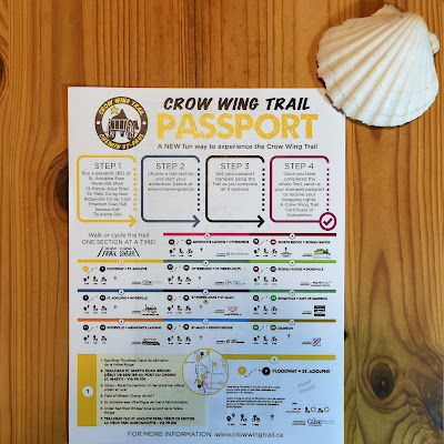
Chmin Saint Paul Camino
The beginning of the Crow Wing Trail also marks the beginning of the Chemin
Saint Paul Camino. It is named after Saint Paul because in the 19th
century the trail connected Fort Garry in Winnipeg with Saint Paul,
Minnesota. The idea behind this Camino is similar to the European Caminos,
the most well-known of which is the Camino de Santiago which runs 850 km from St. Jean-Pied-de-Port, France to Santiago de Compostella, Spain. Like in
Europe, pilgrims along the Chemin St. Paul can collect stamps in a passport
from businesses and establishments along the way, which can be used to obtain a
certificate of completion.


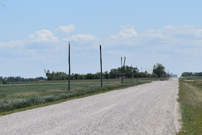
As we set off down the gravel path we passed underneath a road overpass that was full of Cliff Swallow nests underneath. We paused to watch them, and to try to spot some of the Western Meadowlarks that were singing nearby before heading out along the dike that followed the Red River Floodway.


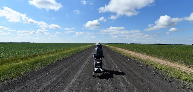
As we walked along the dike in the open grassy landscape, with very few trees in sight, we could see for miles around. Ahead of us a Red-tailed Hawk was soaring in the sky, being chased by a very spunky Red-winged Blackbird. Bees buzzed around the abundant yellow flowers blooming along the trail, and we spotted several monarch butterflies clasped in amorous embraces as they flew through the air.

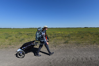

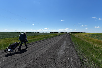
Eventually we turned off the dike onto a dry dirt path. As the wheels of our carts bumped and crunched over the parched, dry, deeply cracked soil we could easily imagine the ox-cart trains of old. Closing our eyes we could smell sweet hay and the clean scent of animals from a distant farm. The hot sun was shining down from above, and we were surrounded by emptiness, with only the sounds of birdsong and the breeze rustling the grass. We felt like we were being transported into the past.


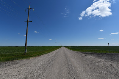
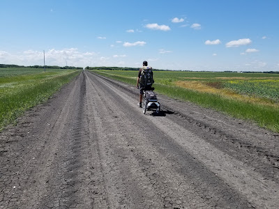
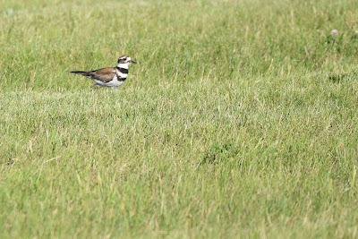
We followed the well-marked trail along white gravel roads that were almost blinding in the bright sun, through grassy fields where we made the unfortunate acquaintance of several ticks, and across soft nearly black dirt roads. We watched Brewer's Blackbirds sunning themselves on pull-offs into the fields, listened to the plaintive cries of Killdeer running in the soy fields, watched a Northern Harrier swooping low over a wheat field, and were taunted by the songs of the invisible Meadowlarks.


Somewhere around 18 km into our hike the trail diverted over into the friendly little community of St. Adolphe. This community was originally called Pointe-Coupée, but was later renamed after Adolphe Turner who made a sizable donation to the local church. This charming town claims the title for having the world's largest snow maze in winter. We were also delighted to learn that it is known as the Chimney Swift nesting capital of Manitoba! Five old brick chimneys remain on four historical buildings in the community, many of which have been restored specifically to provide nesting habitat for the swifts. The Chimney Swift is an internationally threatened species, and this community sits at the northwest edge of its range, so the work being done here is very important!


As the afternoon wore on the heat began to build, and we found it somewhat tough going on the dry, dusty, shadeless roads. We were amazed to see the abundance of Red-winged Blackbirds, House Sparrows, American Goldfinches, American Robins, and Tree Swallows that congregated around even the smallest irrigation ponds. Particular highlights were spotting a bright orange Baltimore Oriole in someone's front yard, and seeing a Western Kingbird (new species!) perched on a utility wire nearby.


By early afternoon the details of the fields, roads, and passing freight trains were obscured by a shimmering heat haze. Each time a car or truck passed by us we were enveloped in a cloud of grey dust. We passed a pile of bones in the grass, bleached white and stripped bare. The wind rustled the wheat at the edge of trail, making a noise almost like sizzling oil, the sun beat down overhead, and our boots crunched along in the gravel. We were left with our own thoughts, and in many ways it felt a lot like crossing the meseta in Spain on the Camino de Santiago.


By mid afternoon, the heat had forced us to take shelter under our trekking umbrellas - two items we had briefly considered leaving in storage this year. As the day wore on , and the trail continued to meander across the landscape we ultimately had to creatively reroute ourselves after finding roads on the Trans Canada Trail closed, bridges missing, and fields fenced off.


By late afternoon we reached the outskirts of Niverville and stopped for a cold iced coffee at Tim Hortons. Longing for a cold shower to wash away the dust and sweat, we called the Niverville Heritage Centre to inquire if there were any lodgings in town for the night, and we were overjoyed to discover they the Heritage Center in fact had some available for those venturing the Crow Wing Trail!


After taking a shower and doing laundry in the sink in our very affordable and truly enormous room, we headed out to Hespeler Park to check out the birding. The Trans Canada and Crow Wing Trails run through the centre of this 90 acre recreation area, which features paved bike paths, soccer fields, baseball diamonds, a large covered picnic area, a playground, and even a free zipline.


Today Niverville is listed as one of the fastest growing communities in Manitoba, and it is easy to see why. Located only 42 km south of Winnipeg, it seems quiet and peaceful, and it offers many opportunities for outdoor recreation, including a large golf course.


As we set off down the gravel path we passed underneath a road overpass that was full of Cliff Swallow nests underneath. We paused to watch them, and to try to spot some of the Western Meadowlarks that were singing nearby before heading out along the dike that followed the Red River Floodway.


As we walked along the dike in the open grassy landscape, with very few trees in sight, we could see for miles around. Ahead of us a Red-tailed Hawk was soaring in the sky, being chased by a very spunky Red-winged Blackbird. Bees buzzed around the abundant yellow flowers blooming along the trail, and we spotted several monarch butterflies clasped in amorous embraces as they flew through the air.


Eventually we turned off the dike onto a dry dirt path. As the wheels of our carts bumped and crunched over the parched, dry, deeply cracked soil we could easily imagine the ox-cart trains of old. Closing our eyes we could smell sweet hay and the clean scent of animals from a distant farm. The hot sun was shining down from above, and we were surrounded by emptiness, with only the sounds of birdsong and the breeze rustling the grass. We felt like we were being transported into the past.


We followed the well-marked trail along white gravel roads that were almost blinding in the bright sun, through grassy fields where we made the unfortunate acquaintance of several ticks, and across soft nearly black dirt roads. We watched Brewer's Blackbirds sunning themselves on pull-offs into the fields, listened to the plaintive cries of Killdeer running in the soy fields, watched a Northern Harrier swooping low over a wheat field, and were taunted by the songs of the invisible Meadowlarks.


Somewhere around 18 km into our hike the trail diverted over into the friendly little community of St. Adolphe. This community was originally called Pointe-Coupée, but was later renamed after Adolphe Turner who made a sizable donation to the local church. This charming town claims the title for having the world's largest snow maze in winter. We were also delighted to learn that it is known as the Chimney Swift nesting capital of Manitoba! Five old brick chimneys remain on four historical buildings in the community, many of which have been restored specifically to provide nesting habitat for the swifts. The Chimney Swift is an internationally threatened species, and this community sits at the northwest edge of its range, so the work being done here is very important!


As the afternoon wore on the heat began to build, and we found it somewhat tough going on the dry, dusty, shadeless roads. We were amazed to see the abundance of Red-winged Blackbirds, House Sparrows, American Goldfinches, American Robins, and Tree Swallows that congregated around even the smallest irrigation ponds. Particular highlights were spotting a bright orange Baltimore Oriole in someone's front yard, and seeing a Western Kingbird (new species!) perched on a utility wire nearby.


By early afternoon the details of the fields, roads, and passing freight trains were obscured by a shimmering heat haze. Each time a car or truck passed by us we were enveloped in a cloud of grey dust. We passed a pile of bones in the grass, bleached white and stripped bare. The wind rustled the wheat at the edge of trail, making a noise almost like sizzling oil, the sun beat down overhead, and our boots crunched along in the gravel. We were left with our own thoughts, and in many ways it felt a lot like crossing the meseta in Spain on the Camino de Santiago.


As the day moved on and the heat continued to rise we were amazed to find that despite the temperature - that had pushed us to find refuge on the side of the road - that hundreds of swallows were flocking around each small bridge we crossed over. Even this little amount of water was enough to provide for their colonies. The perseverance and diversity of nature is amazing!


By mid afternoon, the heat had forced us to take shelter under our trekking umbrellas - two items we had briefly considered leaving in storage this year. As the day wore on , and the trail continued to meander across the landscape we ultimately had to creatively reroute ourselves after finding roads on the Trans Canada Trail closed, bridges missing, and fields fenced off.


The area around Niverville was first developed by Joseph Whitehead in 1874. This railway tycoon spent his own money to build a station on the CPR Emerson line here. In 1877 the Canadian Pacific Railway decided to name his new station after the 18th century explorer and fur trader Joseph-Claude de Niverville.
Niverville was strategically located along the railway line at the western edge of the area being actively settled by Mennonite farmers beginning in 1874. The first grain elevator in Western Canada, a unique round structure, was built here in 1879 to transport barley and other grains to overseas markets.
Niverville was strategically located along the railway line at the western edge of the area being actively settled by Mennonite farmers beginning in 1874. The first grain elevator in Western Canada, a unique round structure, was built here in 1879 to transport barley and other grains to overseas markets.


After taking a shower and doing laundry in the sink in our very affordable and truly enormous room, we headed out to Hespeler Park to check out the birding. The Trans Canada and Crow Wing Trails run through the centre of this 90 acre recreation area, which features paved bike paths, soccer fields, baseball diamonds, a large covered picnic area, a playground, and even a free zipline.


It also features a wastewater management area, and a small adjacent protected marsh area, which support a variety of birds. We were delighted to finally get a good look at the Western Meadowlarks foraging on the mowed lawn of the park, joined by an abundance of Killdeer. A pair of Barn Swallows was nesting in the rafters of a lovely wooden gazebo. We also spotted Baltimore Orioles, Mourning Doves, American Robins, American Goldfinches, Tree Swallows, and House Sparrows. In the ponds we spotted Canada Geese, Mallards, and a couple Canvasbacks calmly paddling around.


Today Niverville is listed as one of the fastest growing communities in Manitoba, and it is easy to see why. Located only 42 km south of Winnipeg, it seems quiet and peaceful, and it offers many opportunities for outdoor recreation, including a large golf course.

Comments
Post a Comment