A Return to Concessions : Asessippi Valley to Roblin
Last night it gently rained on and off, and at one point we heard the sound of coyotes howling in the nearby Asessippi Valley. I didn't get up when the alarm went off at 5:30, hoping the rain would stop, and thankfully it did. When I finally stepped out of the tent to make the coffee the sun was turning the dark clouds pink, and a White-tailed Deer with a budding set of antlers was standing tall atop a sand dune in the hay field outside the tent. A steady stream of American Crows was flying by overhead and complaining loudly, and as I waited for the water to boil a huge Red-tailed Hawk swooped low over the field, giving its iconic screech.
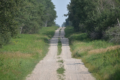
When we headed out we found ourselves on a gravel concession, which was wonderfully shaded by two rows of trembling aspens. Even in their shade it was already hot, but the cool breeze and the sound of the leaves rustling made for a beautiful morning.
In some ways there is little to say about today. We essentially walked straight north for 30 km on the Trans Canada Trail, with only one tiny deviation around a field. We could see the white ribbon of the road stretching out ahead of us, and no matter how far we walked, it always continued straight on to the horizon. We also steadily climbed all day, the road appearing to rise in large undulating steps ahead of us. Unfortunately the concession was newly resurfaced with about 4 inches of fresh gravel, and the effort of pulling the carts up the hills soon became very tiring in the summer's heat.
The highlight of our day occurred when a wonderful local lady pulled up alongside us on the concession to encourage us and wish us well on our travels! Her pure kindness and supportive words helped energize us throughout the day and over the long dusty concessions. Thank you so much!
Although we couldn't see it, we were walking along the eastern shore of the
Lake of the Prairies all day. This 56 km long lake, which is also known
as the Shellmouth Reservoir, is Manitoba's largest reservoir, and it was
created in 1968 as a provincial flood control measure, by damming the
Assiniboine River. The $10.2 million Shellmouth Dam is 21 meters high and
1,300 meters long and can help store 480 million cubic meters of water behind
the spillway. Today the lake has been developed into a premier spot for
anglers that offers walleye, northern pike, yellow perch, common carp, rock
bass, mooneye, and many others. It is lined with cabins, lodges, campgrounds,
and cottages and is a popular spot for vacationers.
The only hint we saw of this large Lake today was a sign for the Prairie Lake
Lodge, which is a golf course, and a few large and odiferous fish that were
spread out on the road and being devoured by small groups of very large
American Crows. It looked like some strange kind of roadkill.
About half way through our hike, in the vicinity of Tummel, we came across a plaque for the Brooks House Historic Site. The house which used to occupy the site was built around 1881 and was owned by Robert and Jane Brooks. They ran a halfway house for travellers on the Pelly Trail, which connected Fort Pelly, Fort Saskatchewan, and Fort Ellice, near St. Lazare Manitoba.
The Pelly trail was an important 19th century route that was used by fur traders and early settlers. The trail ran diagonally from the Fort Ellice Trail, which was farther south, to Fort Pelly, which was the administrative center of the Hudson's Bay Company and was established in 1824 north of Kamsack, Saskatchewan. In 1874 the newly formed North West Mounted Police used the Pelly Trail on their way to establish Fort Livingstone near Fort Pelly.
As we continued to climb the stair-like hills the trembling aspen corridor gradually gave way to open countryside. The lack of shade made the climbing hot, but it was a beautiful landscape of green and yellow rolling hills. About half way to Roblin we noticed a brownish haze setting in, caused by smoke from forest fires west of here, which gradually thickened throughout the afternoon.
As we continued along the concessions we seemed to be walking in a cloud of butterflies. They danced around us in a cloud of delicate white wings, occasionally joined by jewel-like orange individuals and some velvety brown ones. To add to the romantic setting we passed several lovely wooden barns, evoking thoughts of past eras.
As we approached the outskirts of Roblin traffic began to pick up. We were walking parallel to a paved provincial highway, but for reasons that were unclear to us there were still quite a few very large trucks passing us on the steep hills. Despite the best efforts of their drivers these large vehicles left us absolutely covered in dust. Added to the smoke this was rather unpleasant.
At the edges of town we passed several pothole lakes. The first one had a family of Buffleheads paddling about in it. They took fright as we passed, the babies scuttling across the surface of the pond, desperately wind milling their wings to propel themselves away. The next pond had a lone Double-crested Cormorant swimming in it, which looked strangely out of place to me.
Eventually we ducked into a small trail that led into town. We threaded our way through a treed tunnel which looked kind of magical, but was quite overgrown. It brought us out to a large baseball diamond behind the community center, where we gratefully took a break under the shade of the trees. From there it was a short walk around Goose Lake into town.
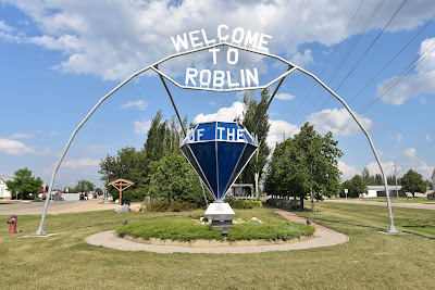
The town of Roblin was settled by European grain farmers and cattle ranchers in the 1880s. It was originally called Goose Lake, but was renamed in 1904 after the Premier of Manitoba, Sir Rodmond Palen Roblin. It is located on Goose Lake, which offers world class Trout Fishing, and was home to the 2010 Canadian Fly Fishing Championships.
See you on the trail!
Remember to follow our entire adventure here : www.comewalkwithus.online


Comments
Post a Comment