Grain Elevators and Prairie Giants : Russell to Inglis
We decided to take it easy today with a more leisurely 26.5 km hike as far as Inglis. We had a slower start, heading out of the beautiful town of Russell around 8:30 am on the 136 km Crocus Trail that connects Russel to the Saskatchewan border.
We followed a crushed stone dust trail bordered by trees through the quiet neighbourhoods. Along the way, we particularly enjoyed the story book section, which told the tale of a very young pigeon who wasn't tired and didn't want to go to sleep, even though it was bed time. You'll have to walk the trail to find out what happens.
In the open, cleared landscape we hiked through a patchwork of brilliant yellow canola fields, lush green alfalfa fields dotted with large round bales of light brown hay, rich golden wheat and barley fields, and a crop that was dappled green, blond, and rusty red as it ripened unevenly. The brightly coloured fields were spread out below a bright blue sky broken only by the occasional wispy white cloud.
Not too long after setting out we passed a prairie pothole with a pair of Red-necked Grebes paddling about. Red-winged Blackbirds moved about in the cattails, a Grey Catbird whined from the shrubs, and an elegant Cedar Waxwing fed on ripe red berries in a nearby bush. Overhead a Red-tailed Hawk soared in lazy circles, its bright red tail glowing against the blue sky.
On today's hike we passed quite a few pastures with beef cattle as well. Although we are ignorant of the cow breeds raised in Canada, we would guess we saw black Angus cows, reddish-brown Heresfords with white faces, and light brown Murray Grey herds. All of them wandered over to check us out.
About 10 km into our hike on the Trans Canada Trail we took a short break outside the treed Minniska Cemetery. Just up hill from this scenic spot was a historic cairn marking the place where the Minniska Presbyterian Church was built in 1899. The first church, which was made of logs, was built at a nearby spot in 1887, and the cairn commemorated the pioneers of the Minniska District who settled this region during that period.
We continued to climb through the rolling hills for another 10 km or so. At one point a very friendly lady drove down the gravel road to ask about our hike and to warn us of a bear she'd seen a few times in the area. When we passed her farm a little later on she and her family waved and wished us well on our travels.
As we took another break beside a bale of hay a red fox stopped on his way across the road to stare at us. Before Sean could get the camera out it had trotted off into a nearby field of barely, heading in the direction of a nearby kettle lake.
In the late afternoon we passed the Zimmer Lakes Wildlife Habitat, preserved by Ducks Unlimited Canada. The wetland stretched out on both sides of the road, although on one side of the narrow gravel concession the trees had been recently cleared along the edges of the wetland and left in tall slash piles. There was a large flock of Greater and Lesser Yellowlegs foraging in the shallow water and mud in the lake, a handful of Killdeer on the shore, and a Ring-billed Gull and two immature Franklin's Gulls floating out in the middle of the water. Several Back Terns seemed to be catching tiny fish in the pond, until they took it upon themselves to chase a Northern Harrier off across the fields.
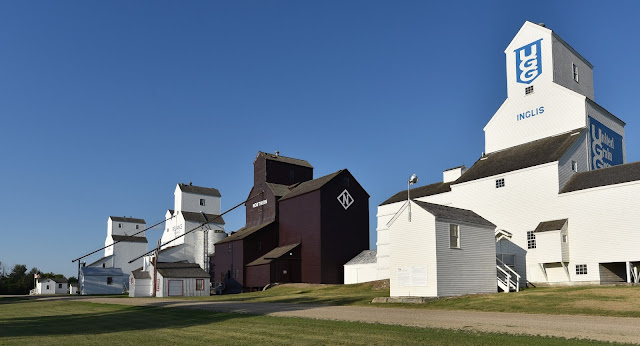
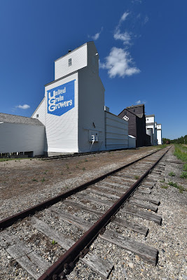
By early afternoon we could see a row of grain elevators standing watch across the fields, indicating that we were approaching the community of Inglis. At the edge of town we stopped to visit the Inglis Grain Elevators National Historic Site of Canada. The group of five standard-plan wooden grain elevators is a rare survivor among the rows of grain elevators that once dominated prairie towns. These slope-shouldered sentinels were built between 1922 and 1941, during the golden age of elevators, and they were once surrounded by outbuildings, the active railway line, and fields of grain.
Wooden grain elevators were introduced to the prairies in the 1880's, and their design didn't change much until the 1970's, when changes in technology and the advent of huge concrete silos began to phase them out. In their heyday, these Prairie Giants were placed 13-16 km apart across the prairie landscape, allowing farmers to make one round trip between the farm and the elevator per day with their horse and wagon. They would bring their grain to the elevator and drive their wagon into the bottom, where it would be weighed. The quality of the grain would be assessed, and a price would be agreed upon. The wagon would then be emptied into a grate in the floor, and the wagon re-weighed to determine the volume of grain sold. A steam-powered conveyor belt fit with buckets, called a leg, would carry the grain to the top of the elevator, where it would be deposited into one of the storage bins. Typical elevators had 12-20 bins that would be filled this way. The grain would be stored until the next train passed through, when gravity would be used to empty the elevator into the railway cars waiting below, which would take it to Winnipeg, Vancouver, or Thunder Bay.
According to the Manitoba Historical Society there were over 700 wooden grain elevators on the prairies in the 1950's, and today there are less than 140 of these powerful symbols of prairie lifestyle and landscape left. Preserving these icons not only teaches future generations about their history, but it also helps us retain an understanding of where our food comes from and a connection to the land. The restoration process is incredibly expensive, and much of it is done by volunteers. It turns out Rick Mercer helped out with re-painting the elevators in Inglis!
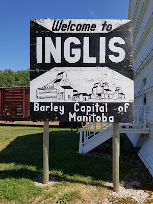
While visiting the National Historic Site we learned that Inglis also claims the title of 'Barley Capital of Manitoba.' It is known for being the best grain and cattle producing area in the province. The unique climate and its central location make Manitoba one of the most productive barley growing areas in the world, and it is also known for its high quality grain.
As we pass through Inglis we find ourselves in the Inter-Parks region of Manitoba. This area is located between Duck Mountain Provincial Park, Asessippi Provincial Park, and Riding Mountain National Park, and there are lots of things to see and do here. Apart from camping, hiking, and cycling in the parks, there is the Frank Skinner Arboretum, the Keystone Pioneer Museum, great fishing and boating on Goose Lake, four golf courses, and in winter there is downhill skiing at Asessippi, snowmobiling, and cross-country skiing.
Tonight we are being hosted by Karen and Rick in a cottage in Inglis. We were delighted to learn that they hosted and remember well Dana Meise, Diane Whelan, and Mel Vogel - all three of the cross-country hikers who precede us on our journey across the country on the Trans Canada Trail. How cool is that?
See you on the trail!
Remember to follow our entire adventure here : www.comewalkwithus.online


Comments
Post a Comment