The Duck Factory : Forest Campsite to beyond Rossburn
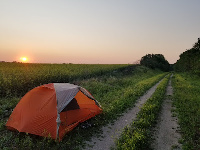
Yesterday was a hard day. Last night was cold, and this morning everything was drenched with dew, including the inside of our tent, which is decidedly no longer waterproof. Leaving the warmth of my sleeping bag to go out and make the morning coffee was unappealing at best, but when I left the tent I was rewarded with the sight of the bright red sun peeking over the hill behind the tent and turning the canola fields golden. As I heated the water, the buzzy call of a Clay-coloured Sparrow sounded from a nearby shrub, and a couple Black-capped Chickadees called good naturedly from the nearby aspens. Despite the challenges of the moment, nature was continuing on. The soft cooing of Mourning Doves drifted over the rolling hills from farther away.
In one of the large ponds we spotted a beaver swimming along, carrying an aspen branch back to its lodge. It noticed us and smacked its tail on the surface of the water with a great splash as it dove. We've noticed beaver lodges on several kettle lakes in this area, and in each case they were built on the shores of the pond rather than in the middle of the waterway, which seems uncharacteristic - or at the very least unexpected from what we have come to see.
A few kilometres into our hike we came across another snowmobile warm-up shelter, although this one was definitely unique. It was in a converted school bus! There were benches and a wood stove in the back, and outside was a portable toilet, a wood pile, and a recycling bin. Pretty cool! The entire setting reminded us of Chris McCandless and his famed "Into the Wild" story.
We continued for a few more kilometres through the breezy and sunny morning, passing some fairly large marshes in the fields as we went. In one of the larger lakes there was an island covered in Double-crested Cormorants and surrounded by American White Pelicans, as well as a wide variety of ducks.
As we crossed Auction Mart Rd we got a bit of a nasty surprise. The Trans Canada Trail went from a nice, hard packed rail trail to an overgrown grassy track, covered in calf deep weeds and grasses. The vegetation was soaking wet with morning dew, and our feet were drenched within a few steps. We soon discovered that the path was again riddled with deep badger holes as well, many of which were hidden by the vegetation. These holes are about 12 inches in diameter and can be several feet deep at the entrance. Every few steps the carts would drop into a hole with a jarring slam, and occasionally we would step into one, risking breaking a leg. To make matters even more interesting, we discovered we are back in a region with a lot of ticks, so they were our constant unwelcome companions throughout the day, requiring us to remove unwanted passengers from our shoes and legs every few hundred meters.
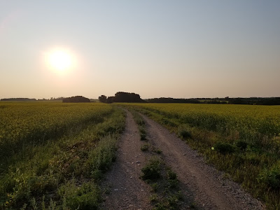
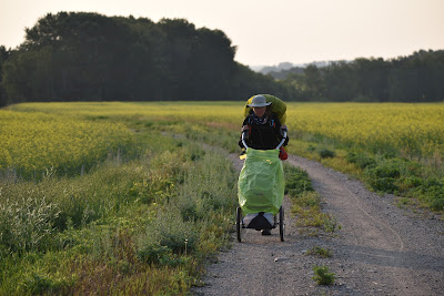
I wish I could say conditions improved, but for most of the next 32 km the vegetation on the trail varied from ankle to waist deep. In many places we found ourselves following a trail of yellow blooming wildflowers, which was oddly beautiful, but it was very tough going. The thick vegetation alone would have been manageable, but avoiding the badger holes required all our concentration. If we looked up at the scenery for even a few seconds SLAM! the cart would drop into a hole. If we let our minds wander for even a moment SLAM! the cart would fall in a hole. Within several hours we both had green bruises in the palms of our hands and chests from the handles of our wheels stabbing back into us when our carts jammed into the ever present holes littering the pathway. We found it very frustrating, and quickly concluded that this section of the trail was suitable for ATVs and snowmobiles, but did not provide a safe or enjoyable experience for hikers, cyclists, or horseback riders.
For most of the day the trail ran parallel to the paved highway, which was about 75 m away across a grassy verge. At one point we tried diverting to the road, but it had an incredibly narrow shoulder and a steep ditch. Given that the sun was shining full in the driver's eyes, and the wind was buffeting the cars, making that option distinctly unsafe. To make matters worse, even at 8 am on this weekend morning, in the kilometre or so we walked on the road, several drivers gave us a friendly salute with a hand that held a beer can. We decided that this stretch of highway was not a safe place for pedestrians early on a Saturday morning, and so we resumed our struggles along the overgrown and badger hole ridden trail.
During one of our many breaks we paused to watch a high speed chase in which two Franklin's Gulls pursued a Bald Eagle. During another break we stopped to lay our gear out to dry in the sun, and stopped to watch a group of Black Terns riding the wind and fishing in a small cattail marsh. The cattails were full of Yellow-headed Blackbirds, and as we listened to them complaining we spotted a tiny Sora moving about at the edge of the reeds. As we sat there, a gigantic - potentially pregnant - Garter Snake slithered along the trail and into a hole.
Around 10 am the wind really picked up. According to the Weather Network we were walking into a 35 kph headwind which was gusting to 50 kph. Moving forward through the weeds and wind was incredibly energy intensive, and to make matters worse the wind was whipping all the grasshoppers we disturbed back in our faces, and the impact was almost painful as they bounced off our chests, noses and foreheads.
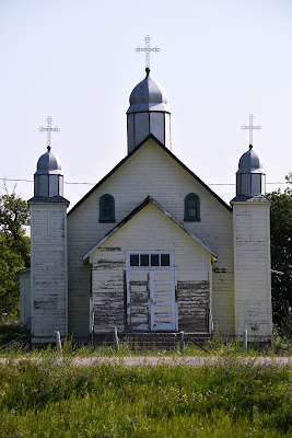
As we approached the tiny community of Menzie, we saw the three beautiful onion domes of a former Ukrainian Orthodox Church rising up beside the road. The church was originally built in 1933, and moved to Menzie from Oakburn in 1947. It is now privately owned. Beside it was located the
Ukrainian National Home which was built in 1920. It was once operated by the Ukrainian Women’s Association, and hosted community recreational functions, Ukrainian language classes, and fundraising events for the adjacent church. It is now a National Historic site, and although it has fallen into disrepair, traces of its former elegance can still be seen.
As we continued to struggle westward we passed many pothole lakes. One was filled with American Coots and Red-necked Grebes. On another we spotted a Blue-winged Teal with a small group of fledglings. At one point we flushed a huge Red-tailed Hawk out of the grasses at the side of the trail. It seemed very strange to see this hawk sitting on the ground, but in an environment without many trees or utility poles, I guess it was natural.
As we continued on we passed a large cattail marsh that extended onto both sides of the highway, and was labelled as the Hersak Wetland and Nature Center. We didn't see a centre, but the marsh was full of waterfowl. This project was supported by Ducks Unlimited Canada, which is dedicated to preserving wetlands for waterfowl, climate, and people. This national organization began 80 years ago in Manitoba, and has now conserved over 22,000 acres of wetlands in this province alone, with the help of over 3,000 volunteers and more than 3,000 landowner partners.
The Prairie Pothole Region, which we are now in, is one of the world's most important waterfowl breeding grounds and is often referred to as Canada's 'Duck Factory'. The wetlands here not only provide important habitat for waterfowl and hundreds of other species, they also provide clean air and water, mitigate climate change, protect against floods and drought, and add to our quality of life. In parts of Manitoba up to 70% of the wetlands have been lost and drainage continues, so the work we saw being done in this marsh and several others today is extremely important.
Sean sat at a shady picnic table at the entrance to the town, beside a conveniently located plug where he took advantage of the much needed opportunity to recharge the battery packs and our cell phone a little. I walked the main street of the small community, which featured a beautifully treed and shaded Lion's Park, a Credit Union, and a General Store. I was surprised to see multiple security cameras and a heavy metal door with several locks and a keypad on the General Store, along with a sign saying the door might be locked during business hours. Despite the fortified exterior, and the heavily caged liquor section, the inside had a wide range of supplies and the proprietor was extremely friendly. Equipped with cold ice tea, ice cream, and homemade cookies for later, I returned to the shaded picnic table.
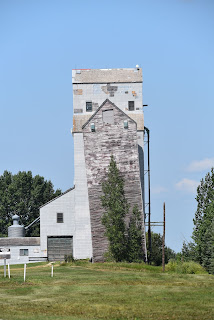
On our way out of town we passed the Pool Grain Elevator, which like many grain elevators in the province is now a Manitoba Historic site. It was built in 1965 on the CNR Rossburn Subdivision Line, with a capacity of 51,000 bushels of grain. Grain elevators are essentially large storage facilities for loose grain, where a bucket elevator or pneumatic conveyor is used to raise grain from lower levels into a silo or storage tank. The grain is then eventually emptied from the storage container into railway cars, trucks, or barges for shipment. The grain elevator in Oakburn, like many others on this route, was closed in 1996 when the adjacent railway line was abandoned. It seems that even this icon of the prairies is now an endangered species being slowly replaced with community museums to an age now past.
After leaving Oakburn we had a 12 km hike to the tiny community of Vista. This section of trail had waist high weeds that were blooming yellow which tangled in the cart wheels and wrapped around our legs, frequently tripping us up. There was a very high density of hidden badger holes, which left our palms bruised from the constant impact of the cart handles as the wheels fell into them. To increase our challenges the wind was blowing us backwards with incredible force. Stunning as it might seem the force of the wind (even when you are wearing leggings with pants over top) is so strong that the soil coats your body from head to toe.
When we dared look up from the trail the wheat and tall grasses in the surrounding fields were rippling like waves in an ocean. It was beautiful and mesmerizing, but no matter how long and hard we struggled we just couldn't make any progress. We began to feel like the community of Vista was a geographical anomaly, with the remaining section being six kilometres away no matter how long we push forward. To add insult to injury, in some sections farmers had mowed the grassy verge between the trail and highway, but for unknown reasons they hadn't mowed the trail. When we tried to walk on the mowed section we just sunk in to the deep, soft, rich agricultural soil. Today was just meant to be a battle against weeds, wind, and badger burrows.
By the late afternoon we were exhausted from the physical exertion and unwavering concentration necessary for trying to avoid the badger holes for so many hours on end. We were also incredibly frustrated from constantly falling into the invisible traps. Fortunately the trail was mowed at the crossroads around Vista, giving us a short break.
There was another rough section after Vista, but one concession before Rossburn the trail was once again mowed and the tire tracks were hard packed and solid. With great relief we finally reached the town, desperately hoping to get something to eat and possibly a place to camp. However as we walked into their community park a gentleman in truck slowed down to inform us that camping was not permitted before driving on. Having now been warned we rested for a few moments before meandering 'downtown' where we discovered that despite the listed hours on Google that the grocery store had closed at 6:00 pm, and that the local restaurants also listed as being open for takeout. It turned out that on this particular Saturday night all were closed.
As we made our way through town a friendly couple stopped to ask if we were looking for the trail, and when we said no we were looking for food, they kindly directed us to the restaurants we had just discovered were closed. When we said this the lady just laughed and said 'Well, that's Rossburn on a Saturday night for you!' Their help was well meant, but it did little to cheer us up.
Tired, hungry, and discouraged we made our way to the Elizabeth Diamond Jubilee Park at the edge of town and on the Trans Canada Trail, and sat at one of the stone picnic tables. We made some flavoured water with the last of our hydration tablets, and ate a bagel with jam - the last of our food supplies.
With nothing left for it, we followed the trail out of town, thankfully on a hard packed, weed free, level rail trail once again. We soon found ourselves climbing into a gorgeous river valley. The steep treed sides of the valley rose on either side, and we could see and hear the river far below us. It felt like we were on a quest in Lord of the Rings. As the sun sank below the lip of the valley we found a flat spot to pitch the tent beside the trail. Another long day on the trail had come to an end.








The section of trail between Sandy Lake and Russell receives relatively little summer traffic (aside from some ATVs as you've seen) compared to more "scenic" and populated sections of TCT. This often coincides with less funding. Perhaps the groups that maintain that section cannot afford to pay for the maintenance of bridge crossings and impeccable summer mowing? From my experience on the TCT, ATV tires that tear up the ground and uproot vegetation are often what keeps the path clear to bike along. Perhaps your findings will agree with this (as much of a nuisance ATVs can be..
ReplyDelete.)
Farmers should not be expected to spend their own fuel and time mowing the TCT. If farmers mow ditches, it is to use it as hay for feed. Ditches (especially along Provincial highways) are usually mowed by contractors to reduce fire risk, improve visibility of hazard wildlife, and sometimes to control invasive/problem vegetation.
Keep up the good work, but please stop embellishing your negative experiences. It is offensive to us who live in rural areas, and have helped out many travelers in need. You make it sound like we're all from Deliverance.