Some Trail, No Trail, Highway : Rapid Pond to Corner Brook
We took this route, which led through an agricultural area, to a farm, and then out onto the road. It was a nice, shaded walk through fields, which are among the first we've seen in Newfoundland up until this point. So far so good, although the sunny day was already getting hot.
We followed Marble Rd past the gated, private community of Humber Village. It was a beautiful walk along the Humber River. To our surprise, as we were plodding along a very nice lady on a bicycle rode up beside us and began to chat. She said she had been following our journey online, and had lots of questions. We had been talking to someone in the area by email, but it turned out to be a friend of hers! Before parting ways Tina offered to give us a lift once we reached Corner Brook, and to help us do laundry. Her kindness and generosity really made our morning!
Eventually Marble Rd brought us to the prosperous town of Steady Brook, which is at the foot of the Marble Mountain ski resort.
As we walked through town we were pleasantly surprised to find a beautiful protected marsh within the town boundaries. The cattail marsh is where the Steady Brook and Humber Rivers merge, and it provides important habitat for several bird species, including Common Goldeneyes, Cedar Waxwings, Pine Siskins, Belted Kingfishers, and American Bitterns. We spotted several American Goldfinches, Red-winged Blackbirds, Black Ducks, a Song Sparrow, and a Hairy Woodpecker during our short visit. This marsh is being protected by the Eastern Habitat Joint Venture, which is a partnership between government and non-government organizations, landowners, and hundreds of other conservation partners. It was great to see a successful example of conservation in action.
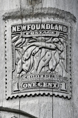
After visiting the marsh we decided to cross under the highway and visit the Newfoundland Heritage Tree. To our surprise we discovered that the tree was actually a totem pole! To us it looked like it could have come straight out of BC, and upon further investigation we discovered it actually had!
The 52 ft tall, 4.5 ft wide, 9 ton totem pole was erected in 1999 to celebrate the Winter Games coming to Corner Brook. The 56 carvings on this incredible work of art tell the history of Newfoundland and Labrador, starting when the Vikings came (999 AD), and including the arrival of John Cabot (1497), the leadership of Joey Smallwood (1949), and the last of the Beothuk, Shanadithit. There are other iconic Newfoundland symbols as well, including an Atlantic Puffin, an iceberg, a Newfoundland 20 cent piece, and Signal Hill. Best all, there is still some empty space left blank to depict future events.
The pole was carved by four artists Bernard Benoit, Scott Butt, Colin Mahoney, and Norman Young, and the giant cedar tree they used to create it was brought by train and transport truck in a collaborative effort from Vancouver Island to the island of Newfoundland.
For us seeing a totem pole on the east coast was unexpected, but in a strange way it affirmed how connected Canada actually is as a nation.
We took quite some time examining the Heritage Tree and taking a break. We then undertook the next stage in today's walk, which was a three kilometre walk down the side of Highway One. The prospect didn't enthuse us much, but it turned out to be quite beautiful. We were not the first to walk the shoulder of the highway, as evidenced by the footprints in the sand on its shoulder, and as we made our way along we were passed by three bicycles and a moped. It really is a trail.
The highway in this section wound through mountains
beside the Humber River. It was picturesque and beautiful, and it could have
been right out of British Columbia.
As we were making our way along behind the guard rail at the edge of the
highway, we came across an adult Spotted Sandpiper and its chicks! We only
caught a glimpse of the tiny fledglings that looked like fluffy pompoms on
legs, but they were extremely cute!
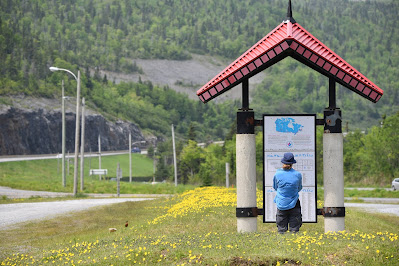
At the end of our stint of highway walking we came to a Great Trail pavilion in a small pull off. There was also an information plaque pointing out an interesting face visible in the rock face of "Old Man Mountain."
From this point on it should have been a relatively easy and straightforward walk in to Corner Brook along Riverside Dr. We started out okay, but after we stopped for an ice cream to try to cool off in rather intense heat, we somehow went wrong. A while later we found ourselves on the wrong side of the harbour, and climbing a hill. Realizing something was amiss we stopped to figured things out.
To make a long, hot, frustrating story short we reached the Grenfell Campus of Memorial University, where we planned to spend the night to do laundry, resupply, dry out, wash our gear, and upload blog entries very late this evening. We hadn't realized that the city of Corner Brook is situated on a series of hills, and the climb up from the harbour is very long and steep. We had an offer of help today, and we didn't accept it. We feel like fools. Hopefully we have learned our lesson, and will be smarter next time!


Comments
Post a Comment